 Filter: Categories of Wisconsin Historical Images
Filter: FULL_DATE of 1953
Filter: Subject of roads
Filter: Categories of Wisconsin Historical Images
Filter: FULL_DATE of 1953
Filter: Subject of roads

| Date: | 1953 |
|---|---|
| Description: | Two children are exiting an International R-183 School Bus. The children are greeted by a woman, possibly their mother. A man, possibly the father of the c... |

| Date: | 1953 |
|---|---|
| Description: | Aerial view of Wonewoc with hills or bluffs in the foreground on the right. |
| Date: | 1953 |
|---|---|
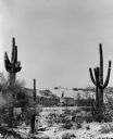
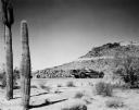
| Description: | Cacti frame three International semis and a pickup on a test track at International Harvester's Phoenix Proving Ground. Opened in 1947, the proving ground ... |
| Date: | 1953 |
|---|---|
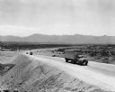
| Description: | International semi trucks mounting a long hill at International Harvester's Phoenix Proving Ground. Opened in 1947, the proving ground was used by Internat... |
| Date: | 1953 |
|---|---|
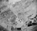
| Description: | Aerial view of International Harvester's Phoenix Proving Ground. Opened in 1947, the proving ground was used by International Harvester through the 1970's ... |
| Date: | 1953 |
|---|---|
| Description: | International Harvester 27-75 earthmover being demonstrated in front of a grandstand at International Harvester's Phoenix Proving Ground. Opened in 1947, t... |

| Date: | 1953 |
|---|---|
| Description: | Bird's-eye view of International Harvester's Phoenix Proving Ground. Opened in 1947, the proving ground was used by International Harvester through the 197... |

| Date: | 1953 |
|---|---|
| Description: | Corner store at Nora on Highway 12 & 18 near Cambridge which sold not only gasoline but also ice cream and soda pop for weary travelers. The Highway Depart... |
| Date: | 1953 |
|---|---|
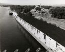
| Description: | Elevated view from bridge of the Diamond Jo warehouse along the Mississippi River shoreline. |

| Date: | 1953 |
|---|---|
| Description: | Color photograph of an International Harvester standard model R-110 truck with a pickup body and ADA-RAK travels down a wooded road. |

| Date: | 1953 |
|---|---|
| Description: | Color photograph of an International R-170 truck with a service utility body parked along the side of a road. A metal ladder is attached to the side of the... |
| Date: | 1953 |
|---|---|
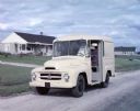
| Description: | View of an International RA-140 milk delivery truck parked along the side of the road, with a milkman in the driver's seat. |
| Date: | 1953 |
|---|---|
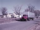
| Description: | Color photograph of a man in a uniform sitting in an International Harvester R-195 semi-truck outfitted with a Space Saver cab. The truck is parked along a... |

| Date: | 1953 |
|---|---|
| Description: | Aerial view looking north from the foot of Milwaukee's main thoroughfare, Wisconsin Avenue. Lincoln Memorial Drive winds its way along the lagoon in Juneau... |
| Date: | 1953 |
|---|---|
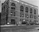
| Description: | View from across street of various representations of the "Don't Buy Cudahy" boycott campaign outside the Packinghouse Workers headquarters: cartops, women... |

| Date: | 1953 |
|---|---|
| Description: | A map of Lake Mendota that shows depths and the locations of various species of fish in lake. The maps also identifies a number of selected roads and stree... |

| Date: | 1953 |
|---|---|
| Description: | This is a detailed map of Douglas County, Wisconsin, showing townships and township borders, numbered wards, roadways, and bodies of water. There are annot... |

| Date: | 1953 |
|---|---|
| Description: | Map shows landownership and acreages, roads, and railroads in the Town of Waukesha and part of the city of Waukesha, Waukesha County, Wisconsin. |

| Date: | 1953 |
|---|---|
| Description: | This mid 20th century map of Vilas County and northeastern Oneida County, Wisconsin, shows the township and range grid, sections, cities and villages, rail... |

| Date: | 1953 |
|---|---|
| Description: | "Compliments of the Douglas County Highway Department"--Top margin. Shows federal highways, state trunk highways, county highways, town roads, unimproved ... |
If you didn't find the material you searched for, our Library Reference Staff can help.
Call our reference desk at 608-264-6535 or email us at: