Filter: Categories of Wisconsin Historical Images
Filter: FULL_DATE of 1953
Filter: Subject of land
Filter: Subject of cities and towns
Filter: Categories of Wisconsin Historical Images
Filter: FULL_DATE of 1953
Filter: Subject of land
Filter: Subject of cities and towns
| Date: | 1953 |
|---|---|
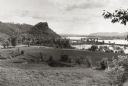
| Description: | View across fields towards the Genoa Dam on the Mississippi River. Tree-covered hills are on the left. |

| Date: | 1953 |
|---|---|
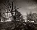
| Description: | Captain John Cotton residence. Also known as "Beaupre," this Greek Revival style house was built in 1842 for Cotton, a retired U.S. Army officer. |

| Date: | 1953 |
|---|---|
| Description: | Aerial view of Wonewoc with hills or bluffs in the foreground on the right. |

| Date: | 1953 |
|---|---|
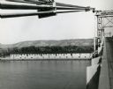
| Description: | Aerial view of La Crosse and the Mississippi River. In the foreground is the new bridge as of 1953. |
| Date: | 1953 |
|---|---|
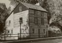
| Description: | A restored Cornish miner's house, called Polperro, on Shake Rag Street. The house was temporarily covered with siding, but after restoration the siding was... |
| Date: | 1953 |
|---|---|
| Description: | View from bridge over the river towards the Diamond Jo warehouse on the shoreline. Hills are in the distance. |

| Date: | 1953 |
|---|---|
| Description: | A map of Lake Mendota that shows depths and the locations of various species of fish in lake. The maps also identifies a number of selected roads and stree... |

| Date: | 1953 |
|---|---|
| Description: | Map shows landownership and acreages, roads, and railroads in the Town of Waukesha and part of the city of Waukesha, Waukesha County, Wisconsin. |

| Date: | 1953 |
|---|---|
| Description: | "Compliments of the Douglas County Highway Department"--Top margin. Shows federal highways, state trunk highways, county highways, town roads, unimproved ... |
| Date: | 1953 |
|---|---|
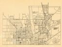
| Description: | This map of Beloit shows existing platted streets or highways and proposed street right of way. The map reads: "I hereby certify that this is the official ... |
| Date: | 1953 |
|---|---|
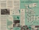
| Description: | This map shows the locations of many scenic areas in La Crosse, Vernon, Crawford, Richland, Grant, and Iowa Counties. On the front side of the map, there i... |
| Date: | 1953 |
|---|---|
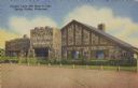
| Description: | Text on front reads: "Crystal Cave Gift Shop & Cafe, Spring Valley, Wisconsin". On reverse it reads: "Crystal Cave, Spring Valley, Wisconsin. Highway Wisco... |
If you didn't find the material you searched for, our Library Reference Staff can help.
Call our reference desk at 608-264-6535 or email us at: