 Filter: Categories of Wisconsin Historical Images
Filter: FULL_DATE of 1953
Filter: Subject of human settlements
Filter: Subject of water
Filter: Categories of Wisconsin Historical Images
Filter: FULL_DATE of 1953
Filter: Subject of human settlements
Filter: Subject of water
| Date: | 1953 |
|---|---|
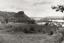
| Description: | View across fields towards the Genoa Dam on the Mississippi River. Tree-covered hills are on the left. |

| Date: | 1953 |
|---|---|
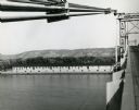
| Description: | Aerial view of La Crosse and the Mississippi River. In the foreground is the new bridge as of 1953. |
| Date: | 1953 |
|---|---|
| Description: | Nemadji River at the foot of 2nd Avenue and Robertson Avenue. A man is standing near the grassy shoreline in the center. |

| Date: | 1953 |
|---|---|
| Description: | View across water towards the Sturgeon Bay Canal Lighthouse, with a group of people in a motorboat in the foreground. |
| Date: | 1953 |
|---|---|
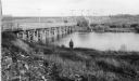
| Description: | View from bridge over the river towards the Diamond Jo warehouse on the shoreline. Hills are in the distance. |

| Date: | 1953 |
|---|---|
| Description: | Aerial view looking north from the foot of Milwaukee's main thoroughfare, Wisconsin Avenue. Lincoln Memorial Drive winds its way along the lagoon in Juneau... |

| Date: | 1953 |
|---|---|
| Description: | A map of Lake Mendota that shows depths and the locations of various species of fish in lake. The maps also identifies a number of selected roads and stree... |

| Date: | 1953 |
|---|---|
| Description: | This is a detailed map of Douglas County, Wisconsin, showing townships and township borders, numbered wards, roadways, and bodies of water. There are annot... |

| Date: | 1953 |
|---|---|
| Description: | This mid 20th century map of Vilas County and northeastern Oneida County, Wisconsin, shows the township and range grid, sections, cities and villages, rail... |

| Date: | 1953 |
|---|---|
| Description: | "Compliments of the Douglas County Highway Department"--Top margin. Shows federal highways, state trunk highways, county highways, town roads, unimproved ... |

| Date: | 1953 |
|---|---|
| Description: | This map is a blue line print and shows streets as well as some points of interest. |

| Date: | 1953 |
|---|---|
| Description: | This map shows local streets, roads, highways, Middleton, Monona, Lake Wingra, Lake Monona, Lake Mendota, and an inset map that shows city parking areas. A... |
| Date: | 1953 |
|---|---|
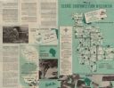
| Description: | This map shows the locations of many scenic areas in La Crosse, Vernon, Crawford, Richland, Grant, and Iowa Counties. On the front side of the map, there i... |

| Date: | 1953 |
|---|---|
| Description: | Illustrated postcard of an elevated view of Monona Bay, the Isthmus and Lake Mendota. A residential neighborhood is in the foreground. Caption reads: "Madi... |

| Date: | 1953 |
|---|---|
| Description: | Snow covered ice extends into the Wisconsin River from the shorelines. Trees line the river bank in the background. |
If you didn't find the material you searched for, our Library Reference Staff can help.
Call our reference desk at 608-264-6535 or email us at: