 Filter: Categories of Wisconsin Historical Images
Filter: FULL_DATE of 1953
Filter: Subject of cities and towns
Filter: Subject of transportation
Filter: Categories of Wisconsin Historical Images
Filter: FULL_DATE of 1953
Filter: Subject of cities and towns
Filter: Subject of transportation

| Date: | 1953 |
|---|---|
| Description: | Aerial view looking southeast over Madison's near east side. The Eagles Club at 1236 Jenifer Street / 1221 Williamson Street is under construction in the ... |
| Date: | 1953 |
|---|---|
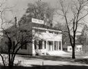
| Description: | View of the Butternut House in the Kohler Foundation restoration project. The service building at the right in the background is operated by the Conservati... |

| Date: | 1953 |
|---|---|
| Description: | Aerial view of Wonewoc with hills or bluffs in the foreground on the right. |

| Date: | 1953 |
|---|---|
| Description: | An aerial view of Wonewoc showing central businesses and a railroad. |

| Date: | 1953 |
|---|---|
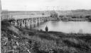
| Description: | Aerial view of La Crosse and the Mississippi River. In the foreground is the new bridge as of 1953. |
| Date: | 1953 |
|---|---|
| Description: | Nemadji River at the foot of 2nd Avenue and Robertson Avenue. A man is standing near the grassy shoreline in the center. |

| Date: | 1953 |
|---|---|
| Description: | View looking northeast along Mifflin Street near its intersection with Carroll Street on the Capitol Square. |

| Date: | 1953 |
|---|---|
| Description: | View across water towards the Sturgeon Bay Canal Lighthouse, with a group of people in a motorboat in the foreground. |
| Date: | 1953 |
|---|---|
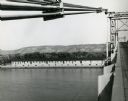
| Description: | View from bridge over the river towards the Diamond Jo warehouse on the shoreline. Hills are in the distance. |

| Date: | 1953 |
|---|---|
| Description: | Aerial view looking north from the foot of Milwaukee's main thoroughfare, Wisconsin Avenue. Lincoln Memorial Drive winds its way along the lagoon in Juneau... |

| Date: | 1953 |
|---|---|
| Description: | Exterior of hospital in winter, with four cars parked in front. |
| Date: | 1953 |
|---|---|
| Description: | View from across street of various representations of the "Don't Buy Cudahy" boycott campaign outside the Packinghouse Workers headquarters: cartops, women... |
| Date: | 1953 |
|---|---|
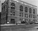
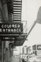
| Description: | Exterior view of the segregated entrance for African-Americans at Malco Theater. There is a fire escape on the side of the building. Several cars are parke... |

| Date: | 1953 |
|---|---|
| Description: | A map of Lake Mendota that shows depths and the locations of various species of fish in lake. The maps also identifies a number of selected roads and stree... |

| Date: | 1953 |
|---|---|
| Description: | This is a detailed map of Douglas County, Wisconsin, showing townships and township borders, numbered wards, roadways, and bodies of water. There are annot... |

| Date: | 1953 |
|---|---|
| Description: | Map shows landownership and acreages, roads, and railroads in the Town of Waukesha and part of the city of Waukesha, Waukesha County, Wisconsin. |

| Date: | 1953 |
|---|---|
| Description: | This mid 20th century map of Vilas County and northeastern Oneida County, Wisconsin, shows the township and range grid, sections, cities and villages, rail... |

| Date: | 1953 |
|---|---|
| Description: | "Compliments of the Douglas County Highway Department"--Top margin. Shows federal highways, state trunk highways, county highways, town roads, unimproved ... |
| Date: | 1953 |
|---|---|
| Description: | This map of Beloit shows existing platted streets or highways and proposed street right of way. The map reads: "I hereby certify that this is the official ... |

| Date: | 1953 |
|---|---|
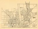
| Description: | This map is a blue line print and shows streets as well as some points of interest. |
If you didn't find the material you searched for, our Library Reference Staff can help.
Call our reference desk at 608-264-6535 or email us at: