Filter: Categories of Wisconsin Historical Images
Filter: FULL_DATE of 1953
Filter: Subject of cities and towns
Filter: Subject of land use
Filter: Categories of Wisconsin Historical Images
Filter: FULL_DATE of 1953
Filter: Subject of cities and towns
Filter: Subject of land use
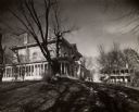
| Date: | 1953 |
|---|---|
| Description: | Dr. William H. Brisbane house, also known as the Thudium house. It was built between 1868 and 1869 from locally quarried stone for Dr. Brisbane, a physicia... |

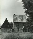
| Date: | 1953 |
|---|---|
| Description: | Replica of Eleazer William's log cabin, with an archeological dig being conducted in front of the cabin. |

| Date: | 1953 |
|---|---|
| Description: | Aerial view looking southeast over Madison's near east side. The Eagles Club at 1236 Jenifer Street / 1221 Williamson Street is under construction in the ... |
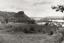
| Date: | 1953 |
|---|---|
| Description: | View across fields towards the Genoa Dam on the Mississippi River. Tree-covered hills are on the left. |

| Date: | 1953 |
|---|---|
| Description: | Captain John Cotton residence. Also known as "Beaupre," this Greek Revival style house was built in 1842 for Cotton, a retired U.S. Army officer. |
| Date: | 1953 |
|---|---|
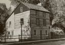
| Description: | A restored Cornish miner's house, called Polperro, on Shake Rag Street. The house was temporarily covered with siding, but after restoration the siding was... |
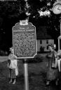
| Date: | 1953 |
|---|---|
| Description: | View of the Governor Louis P. Harvey home marker. Two women are standing behind the sign. A clock is at top right. |
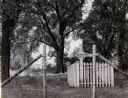
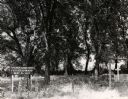
| Date: | 1953 |
|---|---|
| Description: | French Cemetery, showing the grave of Mrs. Alexander Gardipe. |

| Date: | 1953 |
|---|---|
| Description: | Aerial view looking north from the foot of Milwaukee's main thoroughfare, Wisconsin Avenue. Lincoln Memorial Drive winds its way along the lagoon in Juneau... |

| Date: | 1953 |
|---|---|
| Description: | This mid 20th century map of Vilas County and northeastern Oneida County, Wisconsin, shows the township and range grid, sections, cities and villages, rail... |
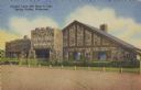
| Date: | 1953 |
|---|---|
| Description: | Text on front reads: "Crystal Cave Gift Shop & Cafe, Spring Valley, Wisconsin". On reverse it reads: "Crystal Cave, Spring Valley, Wisconsin. Highway Wisco... |
If you didn't find the material you searched for, our Library Reference Staff can help.
Call our reference desk at 608-264-6535 or email us at: