 Filter: Categories of Wisconsin Historical Images
Filter: FULL_DATE of 1953
Filter: Subject of cities and towns
Filter: Creator Name of Unknown
Filter: Categories of Wisconsin Historical Images
Filter: FULL_DATE of 1953
Filter: Subject of cities and towns
Filter: Creator Name of Unknown
| Date: | 1953 |
|---|---|
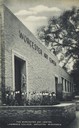
| Description: | View of the front of the art center. Caption reads: "The Worcester Art Center, Lawrence College, Appleton, Wis." |
| Date: | 1953 |
|---|---|
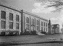
| Description: | The Institute of Paper Chemistry at Lawrence College. |
| Date: | 1953 |
|---|---|
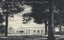
| Description: | View across street toward the union. Caption reads: "The Memorial Union, Lawrence College, Appleton, Wisconsin." |

| Date: | 1953 |
|---|---|
| Description: | Replica of Eleazer William's log cabin, with an archeological dig being conducted in front of the cabin. |

| Date: | 1953 |
|---|---|
| Description: | View looking northeast along Mifflin Street near its intersection with Carroll Street on the Capitol Square. |
| Date: | 1953 |
|---|---|
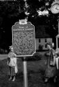
| Description: | View of the Governor Louis P. Harvey home marker. Two women are standing behind the sign. A clock is at top right. |
| Date: | 1953 |
|---|---|
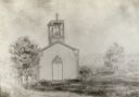
| Description: | Father Mazzuchelli's chapel, St. Augustine's, built before 1850, one of the earliest Catholic churches in Wisconsin. |

| Date: | 1953 |
|---|---|
| Description: | Aerial view looking north from the foot of Milwaukee's main thoroughfare, Wisconsin Avenue. Lincoln Memorial Drive winds its way along the lagoon in Juneau... |

| Date: | 1953 |
|---|---|
| Description: | Buddy Brown poses outdoors standing on a box wearing boxing gloves and trunks. |

| Date: | 1953 |
|---|---|
| Description: | Exterior view of the Lake View Sanitarium, where Lewis Arms's mother Mamie Arms Hall was treated for tuberculosis. |

| Date: | 1953 |
|---|---|
| Description: | Map shows landownership and acreages, roads, and railroads in the Town of Waukesha and part of the city of Waukesha, Waukesha County, Wisconsin. |

| Date: | 1953 |
|---|---|
| Description: | This map shows local streets, roads, highways, Middleton, Monona, Lake Wingra, Lake Monona, Lake Mendota, and an inset map that shows city parking areas. A... |
If you didn't find the material you searched for, our Library Reference Staff can help.
Call our reference desk at 608-264-6535 or email us at: