 Filter: Categories of Wisconsin Historical Images
Filter: FULL_DATE of 1952
Filter: Subject of state parks and reserves
Filter: Categories of Wisconsin Historical Images
Filter: FULL_DATE of 1952
Filter: Subject of state parks and reserves

| Date: | 1952 |
|---|---|
| Description: | The famous Dells of the Wisconsin River. A souvenir map embellished with bits of history and points of interest. |

| Date: | 1952 |
|---|---|
| Description: | This map shows roads, foot and canoe trails, railroads, resorts, lookout towers, camps, national and state forests, Indian reservation, and types of fish i... |

| Date: | 1952 |
|---|---|
| Description: | Winter view of a lake shore road in Peninsula State park. Fresh snow covers the road and trees. |

| Date: | 1952 |
|---|---|
| Description: | Water and reflections at Big Foot Beach State Park on Buttons Bay, Geneva Lake. |

| Date: | 1952 |
|---|---|
| Description: | View through the trees showing the confluence of the Wisconsin and Mississippi Rivers in Wyalusing State Park. |
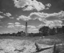
| Date: | 1952 |
|---|---|
| Description: | Rawley Point Lighthouse, located in the Point Beach State Forest. It is 111 feet tall. |
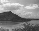
| Date: | 1952 |
|---|---|
| Description: | View of Perrot State Park from the opposite shore of the Mississippi river. |
If you didn't find the material you searched for, our Library Reference Staff can help.
Call our reference desk at 608-264-6535 or email us at: