Filter: Categories of Wisconsin Historical Images
Filter: FULL_DATE of 1952
Filter: Subject of cities and towns
Filter: Categories of Wisconsin Historical Images
Filter: FULL_DATE of 1952
Filter: Subject of cities and towns

| Date: | 1952 |
|---|---|
| Description: | This Wisconsin Conservation Dept. map shows sections, roads, rivers, and lakes in the Town of Cloverland, Vilas County, Wisconsin as of February, 1952. It ... |

| Date: | 1952 |
|---|---|
| Description: | This Wisconsin Conservation Dept. map shows sections, roads, rivers, and lakes in the Town of Presque Isle, Vilas County, Wisconsin as of March 1953. It do... |

| Date: | 1952 |
|---|---|
| Description: | Map shows roads, highways, railroads, parks, city buildings, schools, cemeteries, city limits, and the Fox River. The map is indexed by street name, street... |

| Date: | 1952 |
|---|---|
| Description: | This map of Beaver Dam shows state trunk highway system, county trunk highway system, town roads, rivers, and Beaver Dam Lake and includes an additional at... |

| Date: | 1952 |
|---|---|
| Description: | This map shows roads, foot and canoe trails, railroads, resorts, lookout towers, camps, national and state forests, Indian reservation, and types of fish i... |

| Date: | 1952 |
|---|---|
| Description: | This map shows hunting areas, lakes, rivers, railroads, highways, roads, and trails around Clam Lake, Glidden, and Flambeau Flowage in the north, to Hawkin... |
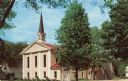
| Date: | 1952 |
|---|---|
| Description: | View from street of the Methodist Church at 213 South Second Street. Congregation established — 1838; Present sanctuary built — 1864; Enlarged and remodele... |

| Date: | 1952 |
|---|---|
| Description: | View across street towards the Ephraim Village Hall. Automobiles are parked on both sides of the street. Text on reverse reads: "A view of Ephraim's pic... |
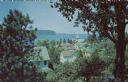
| Date: | 1952 |
|---|---|
| Description: | Kodachrome reproduction of the view over the rooftops of Ephraim towards Eagle Bay. Text on reverse reads: "Portraying the beauty and charm of picturesq... |

| Date: | 1952 |
|---|---|
| Description: | This colored map shows the entire state, along with counties in states bordering Wisconsin. There is a key to "Wisconsin Railroads," with initials identify... |
| Date: | 1952 |
|---|---|
| Description: | View of Washington Street from the intersection of South 19th Street, facing east. On the right, a sign identifies the corner location of the Tankar Gas St... |
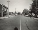
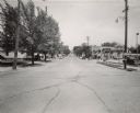
| Date: | 1952 |
|---|---|
| Description: | View of Washington Street from South 18th Street, facing west. Signage identifies the two-story structure on the left as Dunning's Clover Farm Store. Patt... |
| Date: | 1952 |
|---|---|
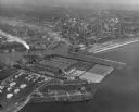
| Description: | Aerial view of the harbor and port facilities. |
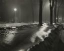
| Date: | 1952 |
|---|---|
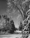
| Description: | Winter view of a lake shore road in Peninsula State park. Fresh snow covers the road and trees. |

| Date: | 1952 |
|---|---|
| Description: | Water and reflections at Big Foot Beach State Park on Buttons Bay, Geneva Lake. |
| Date: | 1952 |
|---|---|
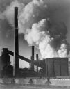
| Description: | Solvay Coke and Gas Company with railroad train and tracks, smoke billowing upward. The company was opened in 1906 and closed in 1983. |
| Date: | 1952 |
|---|---|
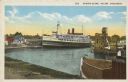
| Description: | Text on front reads: "Harbor Scene, Racine Wisconsin." A large ship is docked in Racine's harbor, with another ship and harbor facilities. |
| Date: | 1952 |
|---|---|
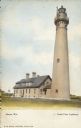
| Description: | Text on front reads: "Racine, Wis.", "North Point Lighthouse". This is actually the Wind Point Lighthouse on Wind Point, located on the north end of Racine... |
| Date: | 1952 |
|---|---|
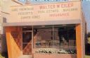
| Description: | Text on reverse reads: "Walter W. Eiler. Three Lakes, Wisconsin. Realtor - Insurance. 'Recreational Real Estate in Northern Wisconsin." A storefront with a... |
If you didn't find the material you searched for, our Library Reference Staff can help.
Call our reference desk at 608-264-6535 or email us at: