 Filter: Categories of Wisconsin Historical Images
Filter: FULL_DATE of 1951
Filter: Subject of water
Filter: Categories of Wisconsin Historical Images
Filter: FULL_DATE of 1951
Filter: Subject of water

| Date: | 1951 |
|---|---|
| Description: | Aerial view of the Nekoosa-Edwards Paper Company nursery. |
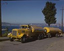
| Date: | 1951 |
|---|---|
| Description: | Color photograph of an International LD-400 series tanker truck owned by Eastern Washington Transports, Inc., on a road near the Port of Seattle. |
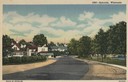
| Date: | 1951 |
|---|---|
| Description: | View down road curving towards Ephraim. Trees are along a lawn on the right near water. Caption reads: "Ephraim, Wisconsin". |

| Date: | 1951 |
|---|---|
| Description: | Aerial view of Jones Island and garbage disposal plant. |
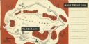
| Date: | 1951 |
|---|---|
| Description: | A drawing of the 5.3 mile race course around Elkhart Lake. Page 12 and 13 of the official program from Elkhart Lake Road Race. The race took place on Sunda... |
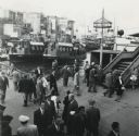
| Date: | 1951 |
|---|---|
| Description: | Elevated view of pedestrians at the harbor at Istanbul, Turkey. |

| Date: | 1951 |
|---|---|
| Description: | Overhead view of Doonga houseboats on the Jhelum River in Pakistan. |

| Date: | 1951 |
|---|---|
| Description: | Boatman on a river in Kashmir. In the background are other boats along a tree-lined shore. |

| Date: | 1951 |
|---|---|
| Description: | Lewis Arms stands at Brittingham Park holding his infant son Lewis Arms, Jr. |

| Date: | 1951 |
|---|---|
| Description: | View from road of the Merrimac ferry approaching shore with several automobiles and a large truck aboard. In the foreground is a sign that reads: "Keep Bac... |

| Date: | 1951 |
|---|---|
| Description: | Water depths shown by bathymetric tints, isolines, and soundings. Relief shown by contours. "Soundings in feet." "Aids to navigation corrected to May 4, 19... |

| Date: | 1951 |
|---|---|
| Description: | Water depths shown by bathymetric tints and soundings. Relief shown by contours. "Depths in feet." "Aids to navigation corrected to May 4, 1951." On verso:... |

| Date: | 1951 |
|---|---|
| Description: | This map of Superior shows labeled streets, waterways, railroads, and company ownership of docks. |

| Date: | 1951 |
|---|---|
| Description: | This map shows Ashland and Washburn harbors in shades of blue and yellow. Water depths shown by isolines and soundings, and relief is shown by contours. Th... |

| Date: | 1951 |
|---|---|
| Description: | This map of Chippewa Falls shows the city of Chippewa River, city limits, roads, highways, fair grounds, and parks. |

| Date: | 1951 |
|---|---|
| Description: | This map of Racine Harbor has relief shown by contours and depths shown by gradient tints and soundings in feet. The map also shows Racine Reef, Wind Point... |

| Date: | 1951 |
|---|---|
| Description: | This map has depths shown by bathymetric tints and soundings and relief shown by contours, the depths are shown in feet. There is an inset map of Green Bay... |

| Date: | 1951 |
|---|---|
| Description: | This map is a survey of Lake Michigan and the section of Milwaukee that borders the lake. Map of land includes major streets, and landmarks near water. Rel... |

| Date: | 1951 |
|---|---|
| Description: | This map shows streets, railroads, Lake Mendota, Lake Monona, Lake Wingra, golf courses, parks, Truax Field, and country clubs. Also included are street, c... |
If you didn't find the material you searched for, our Library Reference Staff can help.
Call our reference desk at 608-264-6535 or email us at:
