Filter: Categories of Wisconsin Historical Images
Filter: FULL_DATE of 1951
Filter: Subject of land
Filter: Categories of Wisconsin Historical Images
Filter: FULL_DATE of 1951
Filter: Subject of land
| Date: | 1951 |
|---|---|
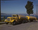
| Description: | Color photograph of an International LD-400 series tanker truck owned by Eastern Washington Transports, Inc., on a road near the Port of Seattle. |
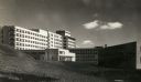
| Date: | 1951 |
|---|---|
| Description: | The Veterans' Administration Hospital, located at 2500 Overlook Terrace. |

| Date: | 1951 |
|---|---|
| Description: | Aerial view of Jones Island and garbage disposal plant. |
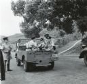
| Date: | 1951 |
|---|---|
| Description: | Hong Kong police with jeep who followed journalist Cecil Brown as he traveled along the border with Communist China. |

| Date: | 1951 |
|---|---|
| Description: | Elinora (mother of Lewis Arms, Jr.) stands in the snow and shoots a rifle, while Walter Arms, uncle of Lewis Arms, looks on. |

| Date: | 1951 |
|---|---|
| Description: | Water depths shown by bathymetric tints and soundings. Relief shown by contours. "Depths in feet." "Aids to navigation corrected to May 4, 1951." On verso:... |

| Date: | 1951 |
|---|---|
| Description: | This map shows Ashland and Washburn harbors in shades of blue and yellow. Water depths shown by isolines and soundings, and relief is shown by contours. Th... |

| Date: | 1951 |
|---|---|
| Description: | This map of Chippewa Falls shows the city of Chippewa River, city limits, roads, highways, fair grounds, and parks. |

| Date: | 1951 |
|---|---|
| Description: | This map of Racine Harbor has relief shown by contours and depths shown by gradient tints and soundings in feet. The map also shows Racine Reef, Wind Point... |

| Date: | 1951 |
|---|---|
| Description: | This map has depths shown by bathymetric tints and soundings and relief shown by contours, the depths are shown in feet. There is an inset map of Green Bay... |

| Date: | 1951 |
|---|---|
| Description: | This map is a survey of Lake Michigan and the section of Milwaukee that borders the lake. Map of land includes major streets, and landmarks near water. Rel... |

| Date: | 1951 |
|---|---|
| Description: | This street map shows public buildings and streets. The lower left corner includes a table of street names and the middle right includes text on the street... |

| Date: | 1951 |
|---|---|
| Description: | This map shows land use, dwellings, resorts, camps, marshes, springs, dams, lake bottom composition, and access. The map includes a fish species table, geo... |

| Date: | 1951 |
|---|---|
| Description: | View from slope towards a farm, with barn, silos, and farmhouse. Caption reads: "Mt. Horeb (Vicinity) Wis. Highway 92, c. 1951-1955." |
| Date: | 1951 |
|---|---|
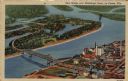
| Description: | Aerial view of a highway bridge crossing the Mississippi River and French Island. Caption reads: "New Bridge over Mississippi River, La Crosse, Wis." |
| Date: | 1951 |
|---|---|
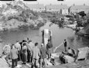
| Description: | Assorted members of a film crew by a lake, during the making of the 1951 film "The African Queen." Two men are standing in the center of the image, holding... |
| Date: | 1951 |
|---|---|
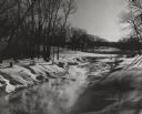
| Description: | View along the snow-covered banks of a creek which is steaming in the extreme cold. There are trees growing in the hilly landscape, and the tops of shrubs ... |
| Date: | 1951 |
|---|---|
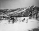
| Description: | View across valley of Mt. Valhalla, a ski hill with two ski jumps. |
| Date: | 1951 |
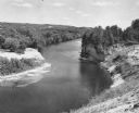
|---|---|
| Description: | Elevated view of the Black River, with rock outcroppings, sand bars and trees. It is approximately 190 miles long and is a tributary of the Mississippi Riv... |
If you didn't find the material you searched for, our Library Reference Staff can help.
Call our reference desk at 608-264-6535 or email us at: