 Filter: Categories of Wisconsin Historical Images
Filter: FULL_DATE of 1951
Filter: Subject of lakes
Filter: Categories of Wisconsin Historical Images
Filter: FULL_DATE of 1951
Filter: Subject of lakes
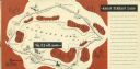
| Date: | 1951 |
|---|---|
| Description: | A drawing of the 5.3 mile race course around Elkhart Lake. Page 12 and 13 of the official program from Elkhart Lake Road Race. The race took place on Sunda... |

| Date: | 1951 |
|---|---|
| Description: | Lewis Arms stands at Brittingham Park holding his infant son Lewis Arms, Jr. |

| Date: | 1951 |
|---|---|
| Description: | Water depths shown by bathymetric tints, isolines, and soundings. Relief shown by contours. "Soundings in feet." "Aids to navigation corrected to May 4, 19... |

| Date: | 1951 |
|---|---|
| Description: | Water depths shown by bathymetric tints and soundings. Relief shown by contours. "Depths in feet." "Aids to navigation corrected to May 4, 1951." On verso:... |

| Date: | 1951 |
|---|---|
| Description: | This map shows Ashland and Washburn harbors in shades of blue and yellow. Water depths shown by isolines and soundings, and relief is shown by contours. Th... |

| Date: | 1951 |
|---|---|
| Description: | This map has depths shown by bathymetric tints and soundings and relief shown by contours, the depths are shown in feet. There is an inset map of Green Bay... |

| Date: | 1951 |
|---|---|
| Description: | This map is a survey of Lake Michigan and the section of Milwaukee that borders the lake. Map of land includes major streets, and landmarks near water. Rel... |

| Date: | 1951 |
|---|---|
| Description: | This map shows streets, railroads, Lake Mendota, Lake Monona, Lake Wingra, golf courses, parks, Truax Field, and country clubs. Also included are street, c... |

| Date: | 1951 |
|---|---|
| Description: | This map shows land use, dwellings, resorts, camps, marshes, springs, dams, lake bottom composition, and access. The map includes a fish species table, geo... |
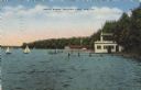
| Date: | 1951 |
|---|---|
| Description: | View across water towards boathouses and piers along the shoreline at Delavan Lake. There are sailboats in the lake. Caption reads: "South Shore, Delavan L... |
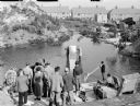
| Date: | 1951 |
|---|---|
| Description: | Assorted members of a film crew by a lake, during the making of the 1951 film "The African Queen." Two men are standing in the center of the image, holding... |
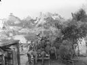
| Date: | 1951 |
|---|---|
| Description: | Film crew gathered during the production of the 1951 film "The African Queen." Three men are pushing a platform on tracks towards a lake. The platform has ... |

| Date: | 1951 |
|---|---|
| Description: | View of Monona Avenue from the southeast entrance of the Capitol. Automobiles are parked along the curbs and both sides of the median. Caption reads: "From... |
If you didn't find the material you searched for, our Library Reference Staff can help.
Call our reference desk at 608-264-6535 or email us at: