 Filter: Categories of Wisconsin Historical Images
Filter: FULL_DATE of 1951
Filter: Subject of human settlements
Filter: Categories of Wisconsin Historical Images
Filter: FULL_DATE of 1951
Filter: Subject of human settlements

| Date: | 1951 |
|---|---|
| Description: | This map shows Ashland and Washburn harbors in shades of blue and yellow. Water depths shown by isolines and soundings, and relief is shown by contours. Th... |

| Date: | 1951 |
|---|---|
| Description: | This map of Chippewa Falls shows the city of Chippewa River, city limits, roads, highways, fair grounds, and parks. |

| Date: | 1951 |
|---|---|
| Description: | This map of Racine Harbor has relief shown by contours and depths shown by gradient tints and soundings in feet. The map also shows Racine Reef, Wind Point... |
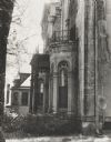
| Date: | 1951 |
|---|---|
| Description: | Front corner detail, showing stone and ironwork of the residence at 424 North Pinckney Street, known as the Pierce house and the Garnhardt house. |

| Date: | 1951 |
|---|---|
| Description: | This map has depths shown by bathymetric tints and soundings and relief shown by contours, the depths are shown in feet. There is an inset map of Green Bay... |

| Date: | 1951 |
|---|---|
| Description: | This map is a survey of Lake Michigan and the section of Milwaukee that borders the lake. Map of land includes major streets, and landmarks near water. Rel... |

| Date: | 1951 |
|---|---|
| Description: | This street map shows public buildings and streets. The lower left corner includes a table of street names and the middle right includes text on the street... |

| Date: | 1951 |
|---|---|
| Description: | This map shows streets, railroads, Lake Mendota, Lake Monona, Lake Wingra, golf courses, parks, Truax Field, and country clubs. Also included are street, c... |

| Date: | 1951 |
|---|---|
| Description: | A platoon of Marines marching down a tree-lined city street. A group of children are walking alongside on the left. |

| Date: | 1951 |
|---|---|
| Description: | This map shows city streets, zoning of city areas, residences, local businesses, and commercial areas marked in red, yellow, and light brown. The bottom ri... |

| Date: | 1951 |
|---|---|
| Description: | Black and white view from street towards the three-story brick high school. Caption reads: "Sr. High School, Ft. Atkinson, Wis." |
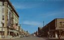
| Date: | 1951 |
|---|---|
| Description: | Colorized postcard view down a street in a main shopping district. Traffic signals are on the corners, and a large flag is hanging from the Beaumont Hotel ... |
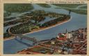
| Date: | 1951 |
|---|---|
| Description: | Aerial view of a highway bridge crossing the Mississippi River and French Island. Caption reads: "New Bridge over Mississippi River, La Crosse, Wis." |
| Date: | 1951 |
|---|---|
| Description: | Illustrated postcard view of the exterior of Bancroft Dairy, and an inset at top left of Charmany Farms. Near the entrance of the dairy are chairs set arou... |

| Date: | 1951 |
|---|---|
| Description: | View of Monona Avenue from the southeast entrance of the Capitol. Automobiles are parked along the curbs and both sides of the median. Caption reads: "From... |
| Date: | 1951 |
|---|---|
| Description: | The Manitowoc Breakwater Lighthouse entered service in 1918, was automated in 1971 and sold in 2009. The lighthouse is located on the end of a 400 foot bre... |
| Date: | 1951 |
|---|---|
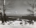
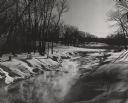
| Description: | View along the snow-covered banks of a creek which is steaming in the extreme cold. There are trees growing in the hilly landscape, and the tops of shrubs ... |
| Date: | 1951 |
|---|---|
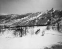
| Description: | View across valley of Mt. Valhalla, a ski hill with two ski jumps. |
| Date: | 1951 |
|---|---|
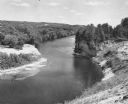
| Description: | Elevated view of the Black River, with rock outcroppings, sand bars and trees. It is approximately 190 miles long and is a tributary of the Mississippi Riv... |

| Date: | 1951 |
|---|---|
| Description: | Text on reverse reads: "'Rock Ledge' Wisconsin's most picturesque gift shop located on the historical site at the Falls of the Sheboygan River, Sheboygan F... |
If you didn't find the material you searched for, our Library Reference Staff can help.
Call our reference desk at 608-264-6535 or email us at: