 Filter: Categories of Wisconsin Historical Images
Filter: FULL_DATE of 1951
Filter: Subject of cities and towns
Filter: Categories of Wisconsin Historical Images
Filter: FULL_DATE of 1951
Filter: Subject of cities and towns

| Date: | 1951 |
|---|---|
| Description: | Aerial view of Jones Island and garbage disposal plant. |
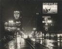
| Date: | 1951 |
|---|---|
| Description: | Wisconsin Avenue at Sixth Street, looking east from near the front of the Milwaukee Public Library (left foreground). Taken at night; lighted clocks read 9... |
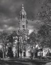
| Date: | 1951 |
|---|---|
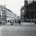
| Description: | N. Jackson Street near Wells Street. Courthouse Square (now Cathedral Square) is in the foreground. |
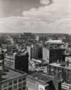
| Date: | 1951 |
|---|---|
| Description: | Elevated view from the First Wisconsin National Bank Building, down Wells Street toward the Milwaukee County Court House. Commerce office on lower left. |

| Date: | 1951 |
|---|---|
| Description: | Exterior of the house at 1609 Porter Avenue shortly after construction. The house was built by Willard Droster. |
| Date: | 1951 |
|---|---|
| Description: | A group of people are gathered on the stairs in front of the main entrance of Bascom Hall (formerly Main Hall) on the University of Wisconsin-Madison campu... |
| Date: | 1951 |
|---|---|
| Description: | Building under construction on the University of Wisconsin-Madison campus. A small storage area with dirt piles, scattered lumber, and support girders for ... |

| Date: | 1951 |
|---|---|
| Description: | Rendering of the Memorial Library building on the University of Wisconsin-Madison campus. The drawing of the building depicts a group of people near the en... |

| Date: | 1951 |
|---|---|
| Description: | Side view of a Joseph H. Brown Iron & Steel Company International Harvester truck decorated with flags and banners for Chicago's East Side Centennial Parad... |
| Date: | 1951 |
|---|---|
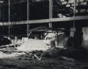
| Description: | A street scene in Berlin that shows the damage caused by wartime bombing. A banner or billboard on the damaged building on the right is advertising a film ... |
| Date: | 1951 |
|---|---|
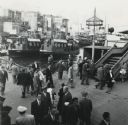
| Description: | Elevated view of pedestrians at the harbor at Istanbul, Turkey. |

| Date: | 1951 |
|---|---|
| Description: | Lewis Arms is sitting in the driver's seat of a 1941(?) DeSoto automobile owned by Joe Brown, as his friend Booker T (standing) looks on. They are at James... |

| Date: | 1951 |
|---|---|
| Description: | Lewis Arms stands at Brittingham Park holding his infant son Lewis Arms, Jr. |

| Date: | 1951 |
|---|---|
| Description: | Water depths shown by bathymetric tints, isolines, and soundings. Relief shown by contours. "Soundings in feet." "Aids to navigation corrected to May 4, 19... |

| Date: | 1951 |
|---|---|
| Description: | Water depths shown by bathymetric tints and soundings. Relief shown by contours. "Depths in feet." "Aids to navigation corrected to May 4, 1951." On verso:... |

| Date: | 1951 |
|---|---|
| Description: | This map shows Ashland and Washburn harbors in shades of blue and yellow. Water depths shown by isolines and soundings, and relief is shown by contours. Th... |

| Date: | 1951 |
|---|---|
| Description: | This map of Chippewa Falls shows the city of Chippewa River, city limits, roads, highways, fair grounds, and parks. |

| Date: | 1951 |
|---|---|
| Description: | This map of Racine Harbor has relief shown by contours and depths shown by gradient tints and soundings in feet. The map also shows Racine Reef, Wind Point... |

| Date: | 1951 |
|---|---|
| Description: | This map has depths shown by bathymetric tints and soundings and relief shown by contours, the depths are shown in feet. There is an inset map of Green Bay... |

| Date: | 1951 |
|---|---|
| Description: | This map is a survey of Lake Michigan and the section of Milwaukee that borders the lake. Map of land includes major streets, and landmarks near water. Rel... |
If you didn't find the material you searched for, our Library Reference Staff can help.
Call our reference desk at 608-264-6535 or email us at: