Filter: Categories of Wisconsin Historical Images
Filter: FULL_DATE of 1950
Filter: Subject of rivers
Filter: Categories of Wisconsin Historical Images
Filter: FULL_DATE of 1950
Filter: Subject of rivers

| Date: | 1950 |
|---|---|
| Description: | Map showing buildings formerly used as Ringling Brothers Circus winter quarters, along with adjoining buildings. |

| Date: | 1950 |
|---|---|
| Description: | Aerial view of fields near neighborhoods. |

| Date: | 1950 |
|---|---|
| Description: | Aerial view of the confluence of the Fox River and Green Bay. |

| Date: | 1950 |
|---|---|
| Description: | Aerial view of the Fox River, near Green Bay. Handwritten locations are marked, including: Site of First Court House, Little Rapids, De Pere. |

| Date: | 1950 |
|---|---|
| Description: | Aerial view of downtown and river. |
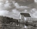
| Date: | 1950 |
|---|---|
| Description: | The Thiensville Mill as seen from the waterfront. |

| Date: | 1950 |
|---|---|
| Description: | An aerial view of town, showing a major industrial area. |
| Date: | 1950 |
|---|---|
| Description: | View of the Wisconsin River dam. |

| Date: | 1950 |
|---|---|
| Description: | State Highway 93 Bridge over the Black River under construction. |
| Date: | 1950 |
|---|---|
| Description: | Grist mill. Two people with bicycles on bridge near mill. |

| Date: | 1950 |
|---|---|
| Description: | Aerial view of the Highway 21 bridge and Petenwell Dam on the Wisconsin River. |

| Date: | 1950 |
|---|---|
| Description: | Looking south. Bridge in foreground is over Kinnickinnic River. Bridge over the road holds railroad tracks. In background are several houses and a build... |

| Date: | 1950 |
|---|---|
| Description: | This map of east central Wisconsin around Lake Winnebago and the southern portion of Green Bay shows the moraines, drumlins, eskers, sand dunes, old beach ... |

| Date: | 1950 |
|---|---|
| Description: | This road map shows federal, state and county roads in Wisconsin, northern Illinois, northeastern Iowa, eastern Minnesota, and the western portion of Michi... |
| Date: | 1950 |
|---|---|
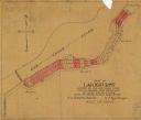
| Description: | This map shows the plat of the village of Lakehurst, on the Red Cedar River in the Town of Tainter, Dunn County, Wisconsin. |

| Date: | 1950 |
|---|---|
| Description: | This map is accompanied by booklet: "Know Milwaukee Map and Street Guide". The map is a detailed map of Milwaukee and the surrounding suburbs. Streets and ... |

| Date: | 1950 |
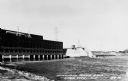
|---|---|
| Description: | Aerial view showing shipyards, rivers and roads. |

| Date: | 1950 |
|---|---|
| Description: | This map of Racine's business section is oriented with the north to the right and shows businesses and lot owners. Businesses, streets, and the Root River ... |
If you didn't find the material you searched for, our Library Reference Staff can help.
Call our reference desk at 608-264-6535 or email us at: