Filter: Categories of Wisconsin Historical Images
Filter: FULL_DATE of 1950
Filter: Subject of michigan, lake
Filter: Categories of Wisconsin Historical Images
Filter: FULL_DATE of 1950
Filter: Subject of michigan, lake

| Date: | 1950 |
|---|---|
| Description: | An aerial view of town, showing a major industrial area. |

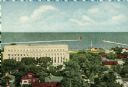
| Date: | 1950 |
|---|---|
| Description: | Harbor area of Jones Island and garbage disposal plant, Stratton Grain Co., and more. |

| Date: | 1950 |
|---|---|
| Description: | This map of east central Wisconsin around Lake Winnebago and the southern portion of Green Bay shows the moraines, drumlins, eskers, sand dunes, old beach ... |

| Date: | 1950 |
|---|---|
| Description: | A map from the Wisconsin identifying the locations airports and other landing facilities in the state. On the opposite side the map includes an alphabetica... |

| Date: | 1950 |
|---|---|
| Description: | This road map shows federal, state and county roads in Wisconsin, northern Illinois, northeastern Iowa, eastern Minnesota, and the western portion of Michi... |

| Date: | 1950 |
|---|---|
| Description: | This map is accompanied by booklet: "Know Milwaukee Map and Street Guide". The map is a detailed map of Milwaukee and the surrounding suburbs. Streets and ... |

| Date: | 1950 |
|---|---|
| Description: | This map of Sturgeon Bay is part of the survey of the northern and northwestern lakes. The map shows lights, railroads, roads, and some public buildings. R... |
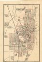
| Date: | 1950 |
|---|---|
| Description: | This map shows streets and waterways and includes annotations in red outlining wards. |
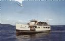
| Date: | 1950 |
|---|---|
| Description: | Color photographic postcard of the "C.G. Richter," a ferry operating between mainland Door County and Washington Island in Wisconsin. |
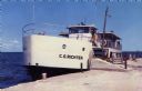
| Date: | 1950 |
|---|---|
| Description: | Color photographic postcard view of the "C.G. Richter" at the dock, a ferry operating between mainland Door County and Washington Island. |
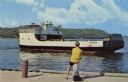
| Date: | 1950 |
|---|---|
| Description: | View from dock towards the Washington Island Ferry, "Eyrarbakki." There is a person sitting on a post on the dock. |

| Date: | 1950 |
|---|---|
| Description: | This map shows regions in Northern Illinois and Southern Wisconsin roughly bounded by Lake Winnebago, the Kankakee River, Peoria, and Prairie du Chien. The... |
If you didn't find the material you searched for, our Library Reference Staff can help.
Call our reference desk at 608-264-6535 or email us at: