 Filter: Categories of Wisconsin Historical Images
Filter: FULL_DATE of 1950
Filter: Subject of landscape
Filter: Categories of Wisconsin Historical Images
Filter: FULL_DATE of 1950
Filter: Subject of landscape
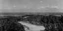
| Date: | 1950 |
|---|---|
| Description: | A view from Rib Mountain looking southeast toward Rothschild and the Wisconsin River. The sign on the road in the foreground reads: "Dangerous Road, Drive ... |
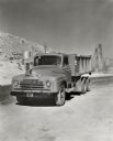
| Date: | 1950 |
|---|---|
| Description: | An International truck owned by the Vowell Material Company parked in a road. There are buildings and rocky terrain in the background. The original caption... |

| Date: | 1950 |
|---|---|
| Description: | Aerial view of a farm and surrounding fields farmed with the contour method. Shocks of grain dot several of the fields. |

| Date: | 1950 |
|---|---|
| Description: | Aerial view of town, showing all of Lake Metonga in the background. Caption reads: "Greetings from Crandon, Wisconsin." |
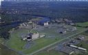
| Date: | 1950 |
|---|---|
| Description: | Aerial view of Sacred Heart Hospital. |

| Date: | 1950 |
|---|---|
| Description: | Aerial view of St. Bede's Priory and High School, including the surrounding country landscape. There is a highway behind the buildings. The Priory is the M... |
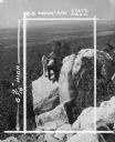
| Date: | 1950 |
|---|---|
| Description: | In this photograph marked for cropping for publication, a group including a young woman, two young men and a boy observe the features of a rock outcropping... |

| Date: | 1950 |
|---|---|
| Description: | View across field towards a man driving a TD-18A. Subject: "TD-18A — Land Clearing." Where Taken: "MidW." Information with photograph reads: "TD-18A Marvin... |
| Date: | 1950 |
|---|---|
| Description: | Subject: "TD-24 — Land Clearing." Where Taken: "Pac." Information with photograph reads: "Owned by Larry Lambertz, Imperial, Calif. Used with a Marvin land... |

| Date: | 1950 |
|---|---|
| Description: | View of a man driving a TD-18A in a field. Subject: "TD-18A — Irrigation." Where Taken: "MidW." Information with photograph reads: "Owned by Brown Bos., Co... |

| Date: | 1950 |
|---|---|
| Description: | View of two men working filling gullies and leveling land. Subject: "TD-14A — Land Clearing." Where Taken: "MidW." Information with photograph reads: "Owne... |
| Date: | 1950 |
|---|---|
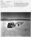
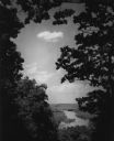
| Description: | Elevated view of the Wisconsin River from Wyalusing State Park, framed by trees. There is a bridge over the river in the distance. |

| Date: | 1950 |
|---|---|
| Description: | Aerial view of contour farming surrounding multiple farms and woods. |
| Date: | 1950 |
|---|---|
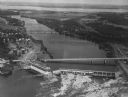
| Description: | Aerial view of a hydroelectric power plant owned by Northern States Power Company located on the Chippewa River. A highway bridge and a railroad bridge spa... |

| Date: | 1950 |
|---|---|
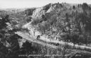
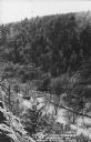
| Description: | Text on front reads: "Horseshoe Curve At Rock Springs, Wis." A road and a railroad track, with bridges over the Baraboo River, make a double curve in an el... |
| Date: | 1950 |
|---|---|
| Description: | Text on front reads: "Upper Narrows, Rock Springs, Wis." A road and a railroad tracks run next to each other in an elevated view of the Upper Narrows. Text... |
| Date: | 1950 |
|---|---|
| Description: | Text on front reads: "The Old Mill Stream in the Narrows at Rock Springs, Wis." A road and the Narrows Creek run next to each other in an elevated view of ... |
| Date: | 1950 |
|---|---|
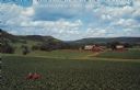
| Description: | Text on front reads: "Greetings from Spring Green, Wis." On the reverse it reads: "Lush Farm Land." Elevated view of a farmer on a tractor in a large corn ... |
If you didn't find the material you searched for, our Library Reference Staff can help.
Call our reference desk at 608-264-6535 or email us at: