 Filter: Categories of Wisconsin Historical Images
Filter: FULL_DATE of 1950
Filter: Subject of landforms
Filter: Categories of Wisconsin Historical Images
Filter: FULL_DATE of 1950
Filter: Subject of landforms

| Date: | 1950 |
|---|---|
| Description: | Aerial view of the Madison isthmus looking north. Caption reads: "Madison Wisconsin — Between Lake Mendota and Lake Monona". |

| Date: | 1950 |
|---|---|
| Description: | Elevated view of the bridge across the Mississippi River between Prairie du Chien, Wisconsin and Marquette, Iowa. Caption reads: "Suspension Bridge Between... |

| Date: | 1950 |
|---|---|
| Description: | This map of east central Wisconsin around Lake Winnebago and the southern portion of Green Bay shows the moraines, drumlins, eskers, sand dunes, old beach ... |

| Date: | 1950 |
|---|---|
| Description: | Aerial view of the Island City surrounded by the waters of Beaver Dam Lake, and by a vacation and recreation area that includes some fifty lakes within a r... |
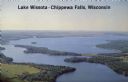
| Date: | 1950 |
|---|---|
| Description: | Aerial view, looking northwest, three miles east of Chippewa Falls, Wisconsin. Big Lake Wissota is seen across from Highway 29 in this color postcard, with... |
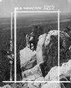
| Date: | 1950 |
|---|---|
| Description: | In this photograph marked for cropping for publication, a group including a young woman, two young men and a boy observe the features of a rock outcropping... |
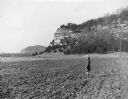
| Date: | 1950 |
|---|---|
| Description: | A young girl wearing a winter coat and hat is standing in a tilled field at the base of Cassell, or Leykauf, Bluff. A description on the reverse of the pri... |

| Date: | 1950 |
|---|---|
| Description: | Castle Rock, surrounded by trees and a meadow. The geological feature is near Volk Field Air National Guard Base. |
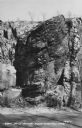
| Date: | 1950 |
|---|---|
| Description: | Text on front reads: "Van Hise Rock, Rock Springs, Wis." The formation has a road along the base with trees growing above. Text on the reverse: "Rock Sprin... |

| Date: | 1950 |
|---|---|
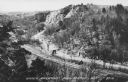
| Description: | Text on front reads: "Horseshoe Curve At Rock Springs, Wis." A road and a railroad track, with bridges over the Baraboo River, make a double curve in an el... |
| Date: | 1950 |
|---|---|
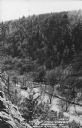
| Description: | Text on front reads: "Upper Narrows, Rock Springs, Wis." A road and a railroad tracks run next to each other in an elevated view of the Upper Narrows. Text... |
| Date: | 1950 |
|---|---|
| Description: | Text on front reads: "The Old Mill Stream in the Narrows at Rock Springs, Wis." A road and the Narrows Creek run next to each other in an elevated view of ... |
| Date: | 1950 |
|---|---|
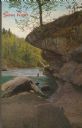
| Description: | Text on front reads: "Sioux River." On reverse: "Big Rock on Sioux River. Washburn, Wisconsin. A thrilling day of trout fishing and picnicking at the Big R... |
If you didn't find the material you searched for, our Library Reference Staff can help.
Call our reference desk at 608-264-6535 or email us at: