 Filter: Categories of Wisconsin Historical Images
Filter: FULL_DATE of 1950
Filter: Subject of express highways
Filter: Categories of Wisconsin Historical Images
Filter: FULL_DATE of 1950
Filter: Subject of express highways

| Date: | 1950 |
|---|---|
| Description: | Divided highway is South Chase Avenue between West Lincoln Avenue (2300) and East Oklahoma Avenue (3100). |

| Date: | 1950 |
|---|---|
| Description: | This road map shows federal, state and county roads in Wisconsin, northern Illinois, northeastern Iowa, eastern Minnesota, and the western portion of Michi... |

| Date: | 1950 |
|---|---|
| Description: | This map shows portions of highway remaining unchanged, proposed relocations, connecting county trunk roads existing or proposed, existing arterials, and e... |
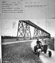
| Date: | 1950 |
|---|---|
| Description: | Subject: "Inter. Super A — Mowing." Where Taken: "SE." Information with photograph reads: "Photo shows first International Super A tractor and AI-23 highwa... |
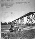
| Date: | 1950 |
|---|---|
| Description: | Subject: "Inter. Super A — Mowing." Where Taken: "SE." Information with photograph reads: "Photo shows first International Super A tractor and AI-23 highwa... |
If you didn't find the material you searched for, our Library Reference Staff can help.
Call our reference desk at 608-264-6535 or email us at: