Filter: Categories of Wisconsin Historical Images
Filter: FULL_DATE of 1950
Filter: Subject of aerial photographs
Filter: Categories of Wisconsin Historical Images
Filter: FULL_DATE of 1950
Filter: Subject of aerial photographs

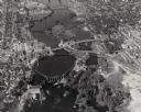
| Date: | 1950 |
|---|---|
| Description: | Aerial view of the Wisconsin State Capitol building and surrounding Madison area. Lake Monona is in the background. |

| Date: | 1950 |
|---|---|
| Description: | Aerial view of the Frank Lloyd-Wright-dsigned Unitarian Church under construction and the Veteran's Administration Hospital, also under construction, to th... |

| Date: | 1950 |
|---|---|
| Description: | Aerial view of main street. There is a bridge with a stream flowing under it in the foreground. |
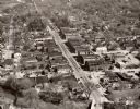
| Date: | 1950 |
|---|---|
| Description: | Aerial view of the main street of town. |

| Date: | 1950 |
|---|---|
| Description: | Aerial view of fields near neighborhoods. |

| Date: | 1950 |
|---|---|
| Description: | Aerial view of the confluence of the Fox River and Green Bay. |

| Date: | 1950 |
|---|---|
| Description: | Aerial view of the Fox River, near Green Bay. Handwritten locations are marked, including: Site of First Court House, Little Rapids, De Pere. |

| Date: | 1950 |
|---|---|
| Description: | Aerial view of downtown and river. |

| Date: | 1950 |
|---|---|
| Description: | An aerial view of town, showing a major industrial area. |

| Date: | 1950 |
|---|---|
| Description: | Aerial view of the Highway 21 bridge and Petenwell Dam on the Wisconsin River. |

| Date: | 1950 |
|---|---|
| Description: | Harbor area of Jones Island and garbage disposal plant, Stratton Grain Co., and more. |

| Date: | 1950 |
|---|---|
| Description: | Divided highway is South Chase Avenue between West Lincoln Avenue (2300) and East Oklahoma Avenue (3100). |
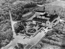
| Date: | 1950 |
|---|---|
| Description: | An aerial view of the monastery, showing a complex of buildings, roads, and the surrounding tree-covered property. A walled garden is between the entrance ... |

| Date: | 1950 |
|---|---|
| Description: | Aerial view of a farm and surrounding fields farmed with the contour method. Shocks of grain dot several of the fields. |

| Date: | 1950 |
|---|---|
| Description: | Aerial view showing shipyards, rivers and roads. |

| Date: | 1950 |
|---|---|
| Description: | Aerial view of town, showing all of Lake Metonga in the background. Caption reads: "Greetings from Crandon, Wisconsin." |

| Date: | 1950 |
|---|---|
| Description: | Aerial view of the Island City surrounded by the waters of Beaver Dam Lake, and by a vacation and recreation area that includes some fifty lakes within a r... |

| Date: | 1950 |
|---|---|
| Description: | Aerial view of the camp, including a numbered index of the buildings. Used as an application form for a forestry workshop. Founded in 1944, located at 519 ... |
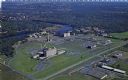
| Date: | 1950 |
|---|---|
| Description: | Aerial view of Sacred Heart Hospital. |
If you didn't find the material you searched for, our Library Reference Staff can help.
Call our reference desk at 608-264-6535 or email us at: