 Filter: Categories of Wisconsin Historical Images
Filter: FULL_DATE of 1950
Filter: Creator Name of Calberne Studio, Inc.
Filter: Categories of Wisconsin Historical Images
Filter: FULL_DATE of 1950
Filter: Creator Name of Calberne Studio, Inc.

| Date: | 1950 |
|---|---|
| Description: | Aerial view of fields near neighborhoods. |

| Date: | 1950 |
|---|---|
| Description: | Aerial view of the confluence of the Fox River and Green Bay. |

| Date: | 1950 |
|---|---|
| Description: | Aerial view of the Fox River, near Green Bay. Handwritten locations are marked, including: Site of First Court House, Little Rapids, De Pere. |

| Date: | 1950 |
|---|---|
| Description: | Aerial view of the Highway 21 bridge and Petenwell Dam on the Wisconsin River. |
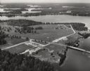
| Date: | 1950 |
|---|---|
| Description: | Aerial view of Northernaire Resort, on Deer Lake. The resort is in the foreground. Many lakes, surrounded by trees, are in the background, including Big St... |
If you didn't find the material you searched for, our Library Reference Staff can help.
Call our reference desk at 608-264-6535 or email us at: