 Filter: Categories of Wisconsin Historical Images
Filter: FULL_DATE of 1948
Filter: Subject of lakes
Filter: Categories of Wisconsin Historical Images
Filter: FULL_DATE of 1948
Filter: Subject of lakes
| Date: | 1948 |
|---|---|
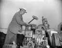
| Description: | John Roach, director of the state beverage and cigarette tax division, using a sledge hammer to smash illegal slot machines. |
| Date: | 1948 |
|---|---|
| Description: | Wisconsin State Capitol from the south side of Monona Bay. |
| Date: | 1948 |
|---|---|
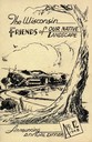
| Description: | Cover for the 1948 Wisconsin Friends of Our Native Landscape program. Depicted is a sketch of a tree, a fence, and a small town by a lake. The Wisconsin Fr... |
| Date: | 1948 |
|---|---|
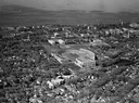
| Description: | Aerial view of Camp Randall Stadium and Field House looking north on the University of Wisconsin-Madison campus with Lake Mendota in the background. |
| Date: | 1948 |
|---|---|
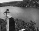
| Description: | View from the east bluff of lake with a motorboat. A geologic pinnacle juts out from the lower left of the image. |

| Date: | 1948 |
|---|---|
| Description: | Aerial view of the Wisconsin State Capitol and surrounding area looking south southeast towards Lake Monona. |
| Date: | 1948 |
|---|---|
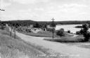
| Description: | View from left side of road towards several buildings and a lake on the right. Down the road automobiles are parked outside of a building with a sign that ... |

| Date: | 1948 |
|---|---|
| Description: | View from a pier of rowboats and a cabin at the Island Resort on Lake Ripley. |
| Date: | 1948 |
|---|---|
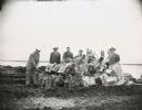
| Description: | Destroying slot machines and other illegal gambling devices at Law Park. From L to R: John Roach, director of the state beverage and cigaret tax division; ... |

| Date: | 1948 |
|---|---|
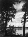
| Description: | The sun is setting in the distance with three small boats docked at the pier. |

| Date: | 1948 |
|---|---|
| Description: | View from Lake Mendota of boathouse on the University of Wisconsin-Madison campus. The Armory (Red Gym or Old Red) is behind the boathouse. A person is sit... |
| Date: | 1948 |
|---|---|
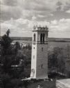
| Description: | Elevated view from building of Carillon Tower on the University of Wisconsin-Madison campus. Lake Mendota and Picnic Point are in the background. There is ... |

| Date: | 1948 |
|---|---|
| Description: | Aerial view of the Elizabeth Waters women's dormitory on the University of Wisconsin-Madison campus. The dorm is also referred to as "Liz" or "The Rock". A... |

| Date: | 1948 |
|---|---|
| Description: | Memorial Union Terrace on the University of Wisconsin-Madison campus. Railing in foreground, with the boathouse tower in the background, with boats tethere... |

| Date: | 1948 |
|---|---|
| Description: | View towards Lake Mendota from the Memorial Union terrace on the University of Wisconsin-Madison campus. |

| Date: | 1948 |
|---|---|
| Description: | View from Bascom Hill of Memorial Union Theater on the University of Wisconsin-Madison campus. Park Street is on the right, and in the background is Lake M... |

| Date: | 1948 |
|---|---|
| Description: | This 1948 map shows contour and spot depths in Lake Wingra in Madison, Wisconsin. The shore outline is based on a 1940 aerial photograph. |
| Date: | 1948 |
|---|---|
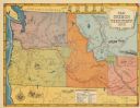
| Description: | This map shows routes of the Old Oregon, Lewis and Clark, Barlow Road, Applegate, Fremont, and Haches Pass trails. Rivers, lakes, and mountains are labeled... |

| Date: | 1948 |
|---|---|
| Description: | This blue line print map shows highways, the scale of traffic volume, and average 24 hour traffic. Also included are inset maps of Appleton, Neenah, and Me... |

| Date: | 1948 |
|---|---|
| Description: | This colored road map shows automobile roads in Wisconsin as well as portions of nearby states.Information on the quality and type of any road shown (bitum... |
If you didn't find the material you searched for, our Library Reference Staff can help.
Call our reference desk at 608-264-6535 or email us at: