 Filter: Categories of Wisconsin Historical Images
Filter: FULL_DATE of 1948
Filter: Subject of cities and towns
Filter: Categories of Wisconsin Historical Images
Filter: FULL_DATE of 1948
Filter: Subject of cities and towns

| Date: | 1948 |
|---|---|
| Description: | Miss Zelma Purchase, of the Home Economics Department at International Harvester's Evansville Works, sits at a table with folded hands. |
| Date: | 1948 |
|---|---|
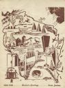
| Description: | Holiday card of the history of the State of Wisconsin, 1848-1948. Shows a map of Wisconsin with many historical and themed elements. Image was created by w... |
| Date: | 1948 |
|---|---|
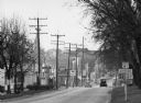
| Description: | "Main (Milwaukee) Street. At this time Hwy 41 was still routed through the village." |
| Date: | 1948 |
|---|---|
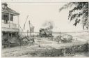
| Description: | Drawing of a passenger train approaching a small town where two teams of horses on a plank road appear to be startled by the noise of the locomotive. One t... |

| Date: | 1948 |
|---|---|
| Description: | Prior to the 1948 State Fair, artist Robert Hodgell traveled Wisconsin to study its many landscapes. He then produced a series of study sketches outlining ... |

| Date: | 1948 |
|---|---|
| Description: | This outline map of Sauk County, Wisconsin, shows the towns, cities and villages, railroads, and streams in the county. |

| Date: | 1948 |
|---|---|
| Description: | Barn on the property of Lyman Copeland Draper on West Washington Avenue. Books which formed the basis for the State Historical Library collections were kep... |

| Date: | 1948 |
|---|---|
| Description: | Map created between 1948 and 1954. Shows businesses and lot owners around the State Capitol. Oriented with north to the upper right. Includes "continued in... |
| Date: | 1948 |
|---|---|
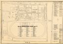
| Description: | This map of the Wisconsin Centennial Exposition is oriented with north to the right. The right hand margin includes "Outstanding Events of the Grandstand P... |

| Date: | 1948 |
|---|---|
| Description: | This map of Milwaukee and surrounding suburbs includes an index to the orange bus, rapid transit, street car, trackless trolley, and the green bus lines. T... |

| Date: | 1948 |
|---|---|
| Description: | This map shows wards and precincts and includes a list of polling places by ward and precinct. The map reads: "Keep this Map . . . It Gives the Location of... |

| Date: | 1948 |
|---|---|
| Description: | This map shows a list of polling places by ward and precinct in the left margin, a list of assembly districts, and additional handwritten notes. Lake Michi... |

| Date: | 1948 |
|---|---|
| Description: | This blue line print map shows lot and block numbers and dimensions, buildings, streets, railroads, and the Wolf River. |

| Date: | 1948 |
|---|---|
| Description: | This map is ink on tracing paper and shows acreages, wards, streets, rivers, and Lake Michigan. Also included are editorial notes in pencil. |

| Date: | 1948 |
|---|---|
| Description: | Three-quarter rear view from right of an American Voluntary Information Services Overseas (AVISO) truck parked outdoors. |

| Date: | 1948 |
|---|---|
| Description: | This illustrated map shows major westward trails from 1785 to 1866: Old Oregon Trail and its deviations, Old Spanish Trail, Lewis and Clark route, Santa Fe... |
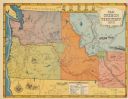
| Date: | 1948 |
|---|---|
| Description: | This map shows routes of the Old Oregon, Lewis and Clark, Barlow Road, Applegate, Fremont, and Haches Pass trails. Rivers, lakes, and mountains are labeled... |
| Date: | 1948 |
|---|---|
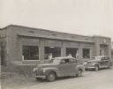
| Description: | Exterior of the Ridgeway Lumber Store before the opening on May 15, 1948. Two cars are parked in front, and merchandise can be seen in the large show windo... |

| Date: | 1948 |
|---|---|
| Description: | This blue line print map shows highways, the scale of traffic volume, and average 24 hour traffic. Also included are inset maps of Appleton, Neenah, and Me... |

| Date: | 1948 |
|---|---|
| Description: | This map shows the land parcels, streets, and parks near the harbor. It includes a wind chart and 7 cross sections of borings/probings and docks. It also i... |
If you didn't find the material you searched for, our Library Reference Staff can help.
Call our reference desk at 608-264-6535 or email us at: