 Filter: Categories of Wisconsin Historical Images
Filter: FULL_DATE of 1948
Filter: County of Milwaukee
Filter: Type of Map or Atlas
Filter: Categories of Wisconsin Historical Images
Filter: FULL_DATE of 1948
Filter: County of Milwaukee
Filter: Type of Map or Atlas
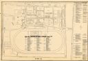
| Date: | 1948 |
|---|---|
| Description: | This map of the Wisconsin Centennial Exposition is oriented with north to the right. The right hand margin includes "Outstanding Events of the Grandstand P... |

| Date: | 1948 |
|---|---|
| Description: | This map of Milwaukee and surrounding suburbs includes an index to the orange bus, rapid transit, street car, trackless trolley, and the green bus lines. T... |

| Date: | 1948 |
|---|---|
| Description: | This map is ink on tracing paper and shows acreages, wards, streets, rivers, and Lake Michigan. Also included are editorial notes in pencil. |

| Date: | 1948 |
|---|---|
| Description: | This map shows the land parcels, streets, and parks near the harbor. It includes a wind chart and 7 cross sections of borings/probings and docks. It also i... |
If you didn't find the material you searched for, our Library Reference Staff can help.
Call our reference desk at 608-264-6535 or email us at: