 Filter: Categories of Wisconsin Historical Images
Filter: FULL_DATE of 1948
Filter: Type of Map or Atlas
Filter: Subject of rivers
Filter: Categories of Wisconsin Historical Images
Filter: FULL_DATE of 1948
Filter: Type of Map or Atlas
Filter: Subject of rivers

| Date: | 1948 |
|---|---|
| Description: | This blue line print map shows lot and block numbers and dimensions, buildings, streets, railroads, and the Wolf River. |

| Date: | 1948 |
|---|---|
| Description: | This map is ink on tracing paper and shows acreages, wards, streets, rivers, and Lake Michigan. Also included are editorial notes in pencil. |

| Date: | 1948 |
|---|---|
| Description: | This illustrated map shows major westward trails from 1785 to 1866: Old Oregon Trail and its deviations, Old Spanish Trail, Lewis and Clark route, Santa Fe... |
| Date: | 1948 |
|---|---|
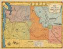
| Description: | This map shows routes of the Old Oregon, Lewis and Clark, Barlow Road, Applegate, Fremont, and Haches Pass trails. Rivers, lakes, and mountains are labeled... |

| Date: | 1948 |
|---|---|
| Description: | This blue line print map shows highways, the scale of traffic volume, and average 24 hour traffic. Also included are inset maps of Appleton, Neenah, and Me... |

| Date: | 1948 |
|---|---|
| Description: | This colored road map shows automobile roads in Wisconsin as well as portions of nearby states.Information on the quality and type of any road shown (bitum... |

| Date: | 1948 |
|---|---|
| Description: | This colored road map shows automobile roads in Wisconsin as well as portions of nearby states. The map is organized such that a single map of Wisconsin is... |
If you didn't find the material you searched for, our Library Reference Staff can help.
Call our reference desk at 608-264-6535 or email us at: