 Filter: Categories of Wisconsin Historical Images
Filter: FULL_DATE of 1947
Filter: Subject of rivers
Filter: Categories of Wisconsin Historical Images
Filter: FULL_DATE of 1947
Filter: Subject of rivers

| Date: | 1947 |
|---|---|
| Description: | The Passenger Pigeon Monument was designed and built around 1947. It was erected by the Wisconsin Society for Ornithology. |

| Date: | 1947 |
|---|---|
| Description: | Aerial view of downtown area, including a river. |

| Date: | 1947 |
|---|---|
| Description: | City Hall near the Milwaukee River. |
| Date: | 1947 |
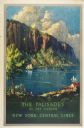
|---|---|
| Description: | An original lithograph promoting "The Palisades of the Hudson," via the New York Central lines train system. The poster depicts a dramatic cliff overlookin... |
| Date: | 1947 |
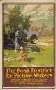
|---|---|
| Description: | An original colored lithograph advertising the London Midland and Scottish Railway Company, and promoting Haddon Hall and the Wye Valley as "The Peak Distr... |

| Date: | 1947 |
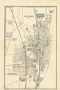
|---|---|
| Description: | Shows lot and block numbers, 28 points of interest in the upper left that correspond to numbers on the map, and landownership with acreages. "Erickson Brot... |

| Date: | 1947 |
|---|---|
| Description: | Lower left hand corner features a legend. "Drawn 1938, revised 1947." Shows water mains, hydrants, corporation limits, city ward divisions, fire proof buil... |

| Date: | 1947 |
|---|---|
| Description: | This map of Wauwatosa shows 10 zoning class types of land including residential, manufacturing, and business. The map also shows government buildings, some... |
| Date: | 1947 |
|---|---|
| Description: | This map of Racine has labeled streets, the Root River, Lake Michigan, and includes manuscript annotations of newly annexed areas and African-American neig... |

| Date: | 1947 |
|---|---|
| Description: | This map shows lakes, rivers, railroads, and the soil types of Langlade County. Legends of soil types, conventional signs, and stoniness and slope are incl... |

| Date: | 1947 |
|---|---|
| Description: | This map shows various types of forests, nurseries, state fish hatcheries, major wood-using industries, camp & picnic grounds, fire towers, ranger stations... |

| Date: | 1947 |
|---|---|
| Description: | View from hill looking down across fields at the property of Charles Grignon. Grignon Mansion in the background among trees, and beyond is the Fox River. O... |

| Date: | 1947 |
|---|---|
| Description: | This map shows territorial roads laid out and opened between 1836 to 1848. Includes a scale in miles. Routes are labeled by numbers and indicated in key on... |

| Date: | 1947 |
|---|---|
| Description: | This map shows the territories of Chippewa, Sioux, Winnebago, and Monomone tribes. It also shows navigation notes for rivers and lakes, Indian villages, hi... |

| Date: | 1947 |
|---|---|
| Description: | Elevated view of the bridge and main building on the opposite shoreline at Pamperin Park. Caption reads: "Pamperin Park, Green Bay, Wis." |

| Date: | 1947 |
|---|---|
| Description: | Mary Griggs (Burke), wearing a patterned short-sleeve blouse, shorts, and a flower in her hair, is sitting in the front of a canoe on the Namakagon River i... |

| Date: | 1947 |
|---|---|
| Description: | Text on front reads: "Greetings-Rice Lake, Wis." A country road curves into the distance next to a river. On the right, a rocky bluff was excavated for the... |
If you didn't find the material you searched for, our Library Reference Staff can help.
Call our reference desk at 608-264-6535 or email us at: