 Filter: Categories of Wisconsin Historical Images
Filter: FULL_DATE of 1947
Filter: Subject of lakes
Filter: Categories of Wisconsin Historical Images
Filter: FULL_DATE of 1947
Filter: Subject of lakes
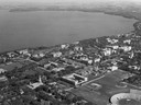
| Date: | 1947 |
|---|---|
| Description: | Aerial of University of Wisconsin-Madison campus with Camp Randall in the lower right corner and Lake Mendota, looking northeast to Maple Bluff. |
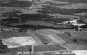
| Date: | 1947 |
|---|---|
| Description: | Aerial view of Lake Seven, surrounded by trees. Agricultural fields fill the foreground. Another lake is in the upper right. Caption reads: "Lake Seven Ade... |

| Date: | 1947 |
|---|---|
| Description: | The Black Hawk Golf Course green, sans golfers. |

| Date: | 1947 |
|---|---|
| Description: | Lake Mendota, looking across University Bay from Willow Drive. The Wisconsin State Capitol is visible in the background. |

| Date: | 1947 |
|---|---|
| Description: | University of Wisconsin-Madison, from Park Street to the men's dormitories. Part of Lake Mendota is in the top right corner. |

| Date: | 1947 |
|---|---|
| Description: | Aerial view of the Elizabeth Waters women's dormitory on the University of Wisconsin-Madison campus. In the upper right corner is Camp Randall. A long pier... |

| Date: | 1947 |
|---|---|
| Description: | An original lithograph promoting Mt. St. Helens, and to get there by way of the Northern Pacific Railway. Featuring the artwork of Gustav Krollmann, it dep... |
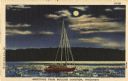
| Date: | 1947 |
|---|---|
| Description: | Colorized postcard of a sailboat in the moonlight. Text below reads: "Greetings From Boulder Junction, Wisconsin." |

| Date: | 1947 |
|---|---|
| Description: | Shows lot and block numbers, 28 points of interest in the upper left that correspond to numbers on the map, and landownership with acreages. "Erickson Brot... |

| Date: | 1947 |
|---|---|
| Description: | This map shows lakes, rivers, railroads, and the soil types of Langlade County. Legends of soil types, conventional signs, and stoniness and slope are incl... |

| Date: | 1947 |
|---|---|
| Description: | This map shows various types of forests, nurseries, state fish hatcheries, major wood-using industries, camp & picnic grounds, fire towers, ranger stations... |

| Date: | 1947 |
|---|---|
| Description: | This map shows territorial roads laid out and opened between 1836 to 1848. Includes a scale in miles. Routes are labeled by numbers and indicated in key on... |

| Date: | 1947 |
|---|---|
| Description: | This map shows the territories of Chippewa, Sioux, Winnebago, and Monomone tribes. It also shows navigation notes for rivers and lakes, Indian villages, hi... |

| Date: | 1947 |
|---|---|
| Description: | View from shoreline of Rocky Roost, a Frank Lloyd Wright-designed cottage on an island in Lake Mendota. A windmill is behind the cottage. Caption reads: "R... |

| Date: | 1947 |
|---|---|
| Description: | View across lake towards cottages on the shoreline surrounded by pine trees. A rowboat and canoe are on the shore. Caption reads: "Echo Lodge, Echo Lake, M... |
If you didn't find the material you searched for, our Library Reference Staff can help.
Call our reference desk at 608-264-6535 or email us at: