Filter: Categories of Wisconsin Historical Images
Filter: FULL_DATE of 1946
Filter: Subject of lakes
Filter: Categories of Wisconsin Historical Images
Filter: FULL_DATE of 1946
Filter: Subject of lakes
| Date: | 1946 |
|---|---|
| Description: | Aerial view of the University of Wisconsin campus with Lake Mendota on the right. |

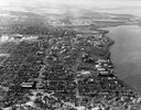
| Date: | 1946 |
|---|---|
| Description: | Aerial view of University of Wisconsin-Madison campus with Bascom Hill area, Observatory Drive and Lake Mendota. |

| Date: | 1946 |
|---|---|
| Description: | View of the Wisconsin State Capitol building and the surrounding area from Lake Monona. |

| Date: | 1946 |
|---|---|
| Description: | University of Wisconsin-Madison campus on isthmus, including the Agricultural campus and men's dormitories. Part of Lake Mendota is in the top right corner... |
| Date: | 1946 |
|---|---|
| Description: | View towards southeast of the University of Wisconsin-Madison on isthmus. Lake Mendota is in the lower left corner, and Lake Monona is in the upper portion... |

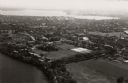
| Date: | 1946 |
|---|---|
| Description: | University of Wisconsin-Madison campus, looking south from Lake Mendota. Camp Randall stadium is in the upper right. |

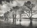
| Date: | 1946 |
|---|---|
| Description: | Colorized postcard of Devil's Lake by moonlight. Two rock formations are in the foreground. The lake, trees, bluffs and sky are in the background. The text... |

| Date: | 1946 |
|---|---|
| Description: | Colorized postcard of Devil's Lake, looking south from the East Trail. Rock formations are in the lower left, with trees below. Bluffs, trees and sky are i... |

| Date: | 1946 |
|---|---|
| Description: | A map showing the roads, railroads, towns, cities and villages, streams and lakes, airports, schools, churches, cemeteries, and golf courses in Kenosha Cou... |

| Date: | 1946 |
|---|---|
| Description: | Map of Kewaunee County, Wisconsin, shows towns, cities and villages, roads and highways, railroads, schools, lighthouses, place names, town divisions, comm... |
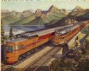
| Date: | 1946 |
|---|---|
| Description: | Reproduction of a painting depicting an Olympian Hiawatha locomotive and an Olympian Hiawatha observation car traveling in the western United States. A man... |

| Date: | 1946 |
|---|---|
| Description: | Color coded map in pink, yellow, green, and brown of Milwaukee County State and County trunk highways. The map includes a legend of symbols: "STEAM RAIL RO... |

| Date: | 1946 |
|---|---|
| Description: | This bird's-eye-view map shows scenes of land use and farming superimposed on a map of the United States. Agricultural scenes of farming, livestock, and cr... |

| Date: | 1946 |
|---|---|
| Description: | This colored road map shows automobile roads in Wisconsin as well as portions of nearby states. Information on the quality and type of any road shown (Inte... |
If you didn't find the material you searched for, our Library Reference Staff can help.
Call our reference desk at 608-264-6535 or email us at: