 Filter: Categories of Wisconsin Historical Images
Filter: FULL_DATE of 1946
Filter: Subject of express highways
Filter: Categories of Wisconsin Historical Images
Filter: FULL_DATE of 1946
Filter: Subject of express highways
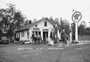
| Date: | 1946 |
|---|---|
| Description: | Two men pose outside Dow's store and filling station on Highway 77. |

| Date: | 1946 |
|---|---|
| Description: | Map of Kewaunee County, Wisconsin, shows towns, cities and villages, roads and highways, railroads, schools, lighthouses, place names, town divisions, comm... |

| Date: | 1946 |
|---|---|
| Description: | Color coded map in pink, yellow, green, and brown of Milwaukee County State and County trunk highways. The map includes a legend of symbols: "STEAM RAIL RO... |
If you didn't find the material you searched for, our Library Reference Staff can help.
Call our reference desk at 608-264-6535 or email us at: