 Filter: Categories of Wisconsin Historical Images
Filter: FULL_DATE of 1945
Filter: Subject of transportation
Filter: Community of Madison
Filter: Categories of Wisconsin Historical Images
Filter: FULL_DATE of 1945
Filter: Subject of transportation
Filter: Community of Madison
| Date: | 1945 |
|---|---|
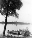
| Description: | View of the Wisconsin State Capitol from across Lake Monona with a tree, pier and boat in the foreground. |

| Date: | 1945 |
|---|---|
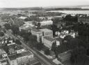
| Description: | View of the lower campus of the University of Wisconsin-Madison includes Bascom Hill, Wisconsin Historical Society, Memorial Union and the Armory (Red Gym ... |

| Date: | 1945 |
|---|---|
| Description: | Aerial view of Bascom Hill, Bascom Hall, Wisconsin Historical Society on the University of Wisconsin Madison campus with Lake Mendota on the right. |
| Date: | 1945 |
|---|---|
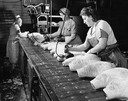
| Description: | Women are stamping hams with the USDA grade stamp and the Oscar Mayer label as the hams move by on an assembly line. |
| Date: | 1945 |
|---|---|
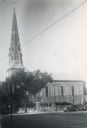
| Description: | View of St. Raphael's Cathedral on West Main Street. |
| Date: | 1945 |
|---|---|
| Description: | An aerial view of Truax Field, now also called Dane County Regional Airport. In addition to commercial flights, Truax Field is also home to the Army Nation... |
| Date: | 1945 |
|---|---|
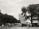
| Description: | View from the corner of Main and Monona Streets looking east toward the Tenney Building. |
| Date: | 1945 |
|---|---|
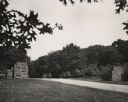
| Description: | University of Wisconsin-Madison entrance to Arboretum. Two stone walls flank the road. Two informational signs, including the speed limit, are past the e... |

| Date: | 1945 |
|---|---|
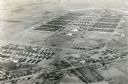
| Description: | Aerial view of married student housing located next to the baseball field near Camp Randall stadium and the Field House. |

| Date: | 1945 |
|---|---|
| Description: | West side of South Hall on the University of Wisconsin-Madison campus. The facade is covered with vines. |
| Date: | 1945 |
|---|---|
| Description: | Elevated view over the Agricultural Campus across University Avenue towards Middleton, on the University of Wisconsin-Madison campus. Lake Mendota is in th... |
| Date: | 1945 |
|---|---|
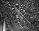
| Description: | Aerial view of Schenk's Corners looking east showing the intersection of Atwood Avenue and Winnebago Street. |

| Date: | 1945 |
|---|---|
| Description: | View down side of railroad tracks towards commercial buildings. Two advertisements are painted on the side of the large brick building in the foreground. |

| Date: | 1945 |
|---|---|
| Description: | This maps shows roads, railroads, parks, recreational areas, Lake Wingra, Lake Monona, and part of Lake Mendota. The map includes pictorial images that dep... |
| Date: | 1945 |
|---|---|
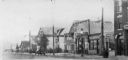
| Description: | View across street towards the even side of the 200 block of Atwood Avenue. Businesses and residences are John Nyberg, a tailor, at 208 1/2 Atwood Avenue, ... |

| Date: | 1945 |
|---|---|
| Description: | An aerial view, looking northeast, that includes the intersection at Atwood and Fair Oaks Avenues. Elmside Circle Park is on the bottom left. The Madison-K... |
If you didn't find the material you searched for, our Library Reference Staff can help.
Call our reference desk at 608-264-6535 or email us at: