 Filter: Categories of Wisconsin Historical Images
Filter: FULL_DATE of 1945
Filter: Subject of neighborhoods
Filter: Categories of Wisconsin Historical Images
Filter: FULL_DATE of 1945
Filter: Subject of neighborhoods
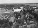
| Date: | 1945 |
|---|---|
| Description: | Aerial view of Madison over the University Avenue-Randall Stadium area, looking toward the Congregationalist Church and the U.S. Forest Products Laboratory... |
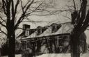
| Date: | 1945 |
|---|---|
| Description: | A view of the Mitchell-Rountree house. Built in 1837 for the Rev. Samueal Mitchell under the direction of his daughter's husband, Major John H. roundtree, ... |

| Date: | 1945 |
|---|---|
| Description: | Aerial view of married student housing located next to the baseball field near Camp Randall stadium and the Field House. |
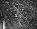
| Date: | 1945 |
|---|---|
| Description: | Aerial view of Schenk's Corners looking east showing the intersection of Atwood Avenue and Winnebago Street. |

| Date: | 1945 |
|---|---|
| Description: | This map shows block and lot numbers, subdivisions, streets, railroads, and abandoned right of ways. Some areas are shown in yellow and pink. The city seal... |

| Date: | 1945 |
|---|---|
| Description: | An aerial view, looking northeast, that includes the intersection at Atwood and Fair Oaks Avenues. Elmside Circle Park is on the bottom left. The Madison-K... |
If you didn't find the material you searched for, our Library Reference Staff can help.
Call our reference desk at 608-264-6535 or email us at: