 Filter: Categories of Wisconsin Historical Images
Filter: FULL_DATE of 1945
Filter: Subject of cities and towns
Filter: Categories of Wisconsin Historical Images
Filter: FULL_DATE of 1945
Filter: Subject of cities and towns
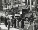
| Date: | 1945 |
|---|---|
| Description: | Me and women line the sidewalks to watch an International Harvester parade float go by. The float is decorated with uniformed men in a jeep, and palm trees... |
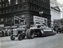
| Date: | 1945 |
|---|---|
| Description: | An International tractor pulls a parade float down a commercial street lined with spectators. The float celebrates International Harvester's war production... |
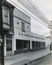
| Date: | 1945 |
|---|---|
| Description: | View from street of the storefront of C.O. Johnson Implement Company, an International Harvester dealership. |
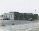
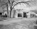
| Date: | 1945 |
|---|---|
| Description: | View from across road of the front of the H.W. Moore Equipment Company, an International Harvester power equipment dealership. Signs on the building read: ... |

| Date: | 1945 |
|---|---|
| Description: | Aerial view of downtown Madison in the before construction of the Wisconsin Telephone Company in 1947 at the corner of South Fairchild Street and East Main... |
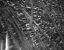
| Date: | 1945 |
|---|---|
| Description: | Aerial view of Schenk's Corners looking east showing the intersection of Atwood Avenue and Winnebago Street. |
| Date: | 1945 |
|---|---|
| Description: | The Du Bois and Kieffer Hudson dealership, and Philbrick Motors, a Willys dealership, which shared a building at 137 Third Avenue. There is a Phillips 66 g... |
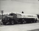
| Date: | 1945 |
|---|---|
| Description: | International KB-8 truck used as oil tanker. The name on the truck reads: "John Groner, Motor Carrier, Inc.; Jefferson City, MO." A dome, possibly the Stat... |
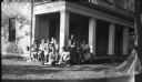
| Date: | 1945 |
|---|---|
| Description: | Visitors to the historic Charles A. Grignon House (built 1837-1839), probably during the 1940s. The visitors are seated on a corner of the front porch unde... |
| Date: | 1945 |
|---|---|
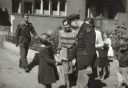
| Description: | Foreign correspondent Alvin J. Steinkopf saying goodbye to Czechoslovakian children after interviewing them about their relief needs. |
| Date: | 1945 |
|---|---|
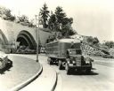
| Description: | International KR-11 truck with semi-trailer on an urban road. A tunnel is in the background with lettering that welcomes visitors to Seattle. |

| Date: | 1945 |
|---|---|
| Description: | View across street of an International K-8 truck in a residential driveway. Original caption reads: "the new type units being operated by Aero Mayflower Tr... |
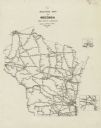
| Date: | 1945 |
|---|---|
| Description: | Map features a legend with symbols of points of interest. The symbols are in red. The back of the map has text on "Points of Interest and Information". |

| Date: | 1945 |
|---|---|
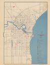
| Description: | This map shows wards and precincts and includes a list of polling places by ward and precinct. The map reads: "Keep this Map . . . It Gives the Location of... |
| Date: | 1945 |
|---|---|
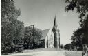
| Description: | Catholic Church with a spire and stairways in front, on a narrow street. Trees and power poles line the street. Caption reads: "Catholic Church, Eagle, Wis... |
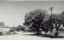
| Date: | 1945 |
|---|---|
| Description: | Crossroads with Hwy 67 straight ahead; the road on the left goes toward Rte. 59 and Oconomowoc. The right turn goes towards Mukwonago. Power lines are over... |
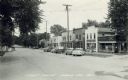
| Date: | 1945 |
|---|---|
| Description: | Diagonal view across Hwy 99 going through Eagle, Wisconsin. Probably Jericho Street, but unmarked. Cars are parked at an angle in front of storefronts lini... |

| Date: | 1945 |
|---|---|
| Description: | Dickey Chapelle wearing a heavy coat and kneeling to feed hay to a donkey next to a cart on a street in a city in Geurande, France. She has a camera around... |
| Date: | 1945 |
|---|---|
| Description: | This map shows railroad routes and includes inset maps of Superior and vicinity and Milwaukee and vicinity. |

| Date: | 1945 |
|---|---|
| Description: | This map shows block and lot numbers, subdivisions, streets, railroads, and abandoned right of ways. Some areas are shown in yellow and pink. The city seal... |
If you didn't find the material you searched for, our Library Reference Staff can help.
Call our reference desk at 608-264-6535 or email us at: