 Filter: Categories of Wisconsin Historical Images
Filter: FULL_DATE of 1943
Filter: Subject of rivers
Filter: Categories of Wisconsin Historical Images
Filter: FULL_DATE of 1943
Filter: Subject of rivers

| Date: | 1943 |
|---|---|
| Description: | This photocopy map shows inhabited farms, rivers, roads, and mills in the vicinity of Marathon City [and village of Edgar], including area between the Big ... |

| Date: | 1943 |
|---|---|
| Description: | Soldiers in battle gear, holding rifles, marching in a long line across a wooden bridge. Across the water is a building on the shoreline with the jungle be... |
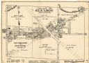
| Date: | 1943 |
|---|---|
| Description: | This map of the Village of Gleason shows land ownership by name, local streets, railroads, churches, schools, and part of Prairie River. The bottom left of... |
If you didn't find the material you searched for, our Library Reference Staff can help.
Call our reference desk at 608-264-6535 or email us at: