 Filter: Categories of Wisconsin Historical Images
Filter: FULL_DATE of 1942
Filter: Categories of Wisconsin Historical Images
Filter: FULL_DATE of 1942

| Date: | 1942 |
|---|---|
| Description: | This map shows the route of the Milwaukee Road, roads, foot trails, resorts, and ranger stations. The map includes text, illustrations, a railroad fare tab... |

| Date: | 1942 |
|---|---|
| Description: | Quarter-length portrait of Zilphia Horton, wife of Myles Horton, the founder of Highlander Folk School. |

| Date: | 1942 |
|---|---|
| Description: | This map shows surfaces and types of highways. A legend and three county and two local area inset maps are included. The bottom left margin reads: "Traffi... |
| Date: | 1942 |
|---|---|
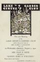
| Description: | Printed invitation announcing a meeting of the Lake Geneva Garden Club to be held at the home of Mrs. Alfred F. Madlener. It features a stylized drawing of... |
| Date: | 1942 |
|---|---|
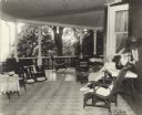
| Description: | Alma Schmidt Petersen poses seated in a wicker chair on the porch at Black Point. She is wearing a dress and light coat. There is a large-leafed potted pla... |
| Date: | 1942 |
|---|---|
| Description: | A portrait of Dr. Otto L. Schmidt hangs in the front hall of Black Point. A handwritten caption which accompanies the photograph states: "Portrait above — ... |

| Date: | 1942 |
|---|---|
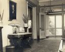
| Description: | A grandfather clock stands to the left of the stairway in the front hall of Black Point. There is a paneled door in the background and a settee on the righ... |

| Date: | 1942 |
|---|---|
| Description: | Two tall bookcases stand against the far wall in the living room at Black Point. A portrait of Conrad Seipp hangs on that wall. A large bouquet in a tall v... |
| Date: | 1942 |
|---|---|
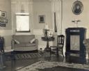
| Description: | An oval portrait of Emma Seipp Schmidt hangs above a cabinet in the music room at Black Point. A modern style settee stands in the large window bay. |
| Date: | 1942 |
|---|---|
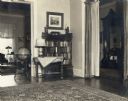
| Description: | A view of a corner of the living room at Black Point provides a glimpse into the music room, at left, and the front hall, right. In the living room is a bo... |

| Date: | 1942 |
|---|---|
| Description: | This pictorial bird's-eye-view map shows the United States of America with parts of Canada and Mexico. Landscape, trade, industry, points of interest, peop... |

| Date: | 1942 |
|---|---|
| Description: | Mrs. Mabel Arbogast of Eldon, Mo., driving a Farmall A pulling a disk harrow through rye on the farm of Mr. E. Arbogast. She is sitting on a sheepskin seat... |

| Date: | 1942 |
|---|---|
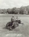
| Description: | Slightly elevated three-quarter view from right front of a man driving a Farmall A tractor with a disk harrow through a field dotted with corn shocks. In t... |
| Date: | 1942 |
|---|---|
| Description: | Man using Farmall A and mower, owned by J.W. Mead. |
| Date: | 1942 |
|---|---|
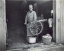
| Description: | A man is standing in the open doorway of a farm building using a hand-cranked sheller for corn for horses and calves. There is a galvanized bucket undernea... |

| Date: | 1942 |
|---|---|
| Description: | This map shows a paper city laid out in 1836 on the Wisconsin River, now the site of Wyalusing State Park, Grant County. The upper right corner includes a ... |

| Date: | 1942 |
|---|---|
| Description: | This photostat map shows roads, ferry, impassible marsh land, the Menominee River, the Milwaukee River, and Lake Michigan. |

| Date: | 1942 |
|---|---|
| Description: | This photocopy plat map represents the relative position and size of the sloughs and islands in the Mississippi River, opposite Prairie du Chien. |

| Date: | 1942 |
|---|---|
| Description: | Carson Gulley putting on the ninth hole at the Westmorland Golf Course (1929-1944) in the 4200 block of Mineral Point Road as another man looks on. Several... |
| Date: | 1942 |
|---|---|
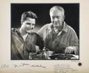
| Description: | Illustration of an airbrushed composite photograph picturing an older worker standing with his arm around a young man and pointing to a machine. |
If you didn't find the material you searched for, our Library Reference Staff can help.
Call our reference desk at 608-264-6535 or email us at: