 Filter: Categories of Wisconsin Historical Images
Filter: FULL_DATE of 1942
Filter: Subject of transportation
Filter: Categories of Wisconsin Historical Images
Filter: FULL_DATE of 1942
Filter: Subject of transportation
| Date: | 1942 |
|---|---|
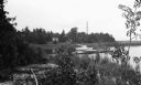
| Description: | A sailboat is moored to a wooden pier at North Bay. There is an old wooden building in the background across a marsh area. |
| Date: | 1942 |
|---|---|
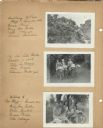
| Description: | Views of two different bike hosteling trips to Pine Bluff (Dane County) and Lake Mills (Jefferson County), sponsored by Neighborhood House, with girls rest... |

| Date: | 1942 |
|---|---|
| Description: | Four participants (Mary Lou Ciulla, Annie Gambino, Bessie Parisi, and Vita Valenza) of a bike hosteling trip sponsored by Neighborhood House, resting on a ... |

| Date: | 1942 |
|---|---|
| Description: | This 1942 map of the Town of Middleton, Dane County, Wisconsin, shows sections, landowners, highways and roads, a railroad, the village of Middleton, and l... |
| Date: | 1942 |
|---|---|
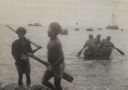
| Description: | Indigenous men help 32nd Division soldiers from units, originally from Wisconsin, who paddle in collapsible canvas boats to small coastal vessels. The man ... |
| Date: | 1942 |
|---|---|
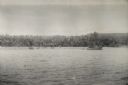
| Description: | View over water towards the New Guinea coast from a boat. A larger boat is on the right and several smaller craft in the center. A pier is on the shoreline... |

| Date: | 1942 |
|---|---|
| Description: | This map of Burlington shows plat of the town, city limits, section lines, 1/4 section lines of the plat sections, roads, railroads, rivers, and lakes. The... |

| Date: | 1942 |
|---|---|
| Description: | A detail of a Madison Sanborn map, including Lakelawn Place. |

| Date: | 1942 |
|---|---|
| Description: | Detail of a Madison Sanborn Map showing the Lake Mendota shoreline. The area shown is between the Blackhawk Country Club and Eagle Heights Woods. |

| Date: | 1942 |
|---|---|
| Description: | This map shows the route of the Milwaukee Road, roads, foot trails, resorts, and ranger stations. The map includes text, illustrations, a railroad fare tab... |

| Date: | 1942 |
|---|---|
| Description: | This map shows surfaces and types of highways. A legend and three county and two local area inset maps are included. The bottom left margin reads: "Traffi... |

| Date: | 1942 |
|---|---|
| Description: | This pictorial bird's-eye-view map shows the United States of America with parts of Canada and Mexico. Landscape, trade, industry, points of interest, peop... |

| Date: | 1942 |
|---|---|
| Description: | This map shows a paper city laid out in 1836 on the Wisconsin River, now the site of Wyalusing State Park, Grant County. The upper right corner includes a ... |

| Date: | 1942 |
|---|---|
| Description: | This photostat map shows roads, ferry, impassible marsh land, the Menominee River, the Milwaukee River, and Lake Michigan. |
| Date: | 1942 |
|---|---|
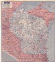
| Description: | This colored road map shows automobile roads in Wisconsin as well as portions of nearby states. Information on the quality and type of any road shown (pave... |

| Date: | 1942 |
|---|---|
| Description: | Black and white aerial view of La Crosse and the Mississippi River, including Riverside Park, the Black River and La Crosse River. |

| Date: | 1942 |
|---|---|
| Description: | Mary Griggs (Burke) is wearing a one-piece bathing suit as she climbs out of Lake Namakagon onto the Forest Lodge boathouse deck while her dachshund awaits... |

| Date: | 1942 |
|---|---|
| Description: | Text on front reads: "Hotel Sydney - Sparta, Wis. European - Modern - Dining Room." View from intersection of a two-story hotel with three-story towers on ... |
| Date: | 1942 |
|---|---|
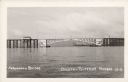
| Description: | Text on front reads: "Arrowhead Bridge, Duluth-Superior Harbor. The bridge connected Superior, Wisconsin, with Duluth, Minnesota, over the St. Louis River.... |
| Date: | 1942 |
|---|---|
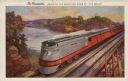
| Description: | Text on front: "The Hiawatha. Crossing the Wisconsin River at the 'Dells'." On reverse: "The Scenic Route. The Milwaukee Road is the only double tracked ro... |
If you didn't find the material you searched for, our Library Reference Staff can help.
Call our reference desk at 608-264-6535 or email us at: