 Filter: Categories of Wisconsin Historical Images
Filter: FULL_DATE of 1942
Filter: Subject of michigan, lake
Filter: Categories of Wisconsin Historical Images
Filter: FULL_DATE of 1942
Filter: Subject of michigan, lake

| Date: | 1942 |
|---|---|
| Description: | This map shows the Wisconsin and Fox River routes in green, and the Milwaukee and Rock River Canal routes in red. Prairie du Chien, Fort Winnebago, Grand C... |
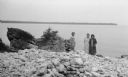
| Date: | 1942 |
|---|---|
| Description: | The photographer's daughter, Helen Hotz Schmid, left, and granddaughter, Margaret Schmid, right, pose at water's edge with Nenn Steck Hotz at Toft Point ne... |
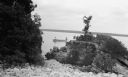
| Date: | 1942 |
|---|---|
| Description: | View from rocky shoreline of two men fishing from a small boat near Toft Point. |
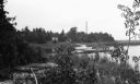
| Date: | 1942 |
|---|---|
| Description: | A sailboat is moored to a wooden pier at North Bay. There is an old wooden building in the background across a marsh area. |

| Date: | 1942 |
|---|---|
| Description: | This map shows the route of the Milwaukee Road, roads, foot trails, resorts, and ranger stations. The map includes text, illustrations, a railroad fare tab... |

| Date: | 1942 |
|---|---|
| Description: | This map shows surfaces and types of highways. A legend and three county and two local area inset maps are included. The bottom left margin reads: "Traffi... |

| Date: | 1942 |
|---|---|
| Description: | This photostat map shows roads, ferry, impassible marsh land, the Menominee River, the Milwaukee River, and Lake Michigan. |
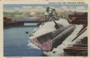
| Date: | 1942 |
|---|---|
| Description: | View of a submarine launch at the Manitowoc shipyards. Caption reads: "Launching of the "Peto", Manitowoc, Wis." |
If you didn't find the material you searched for, our Library Reference Staff can help.
Call our reference desk at 608-264-6535 or email us at: