 Filter: Categories of Wisconsin Historical Images
Filter: FULL_DATE of 1942
Filter: Type of Map or Atlas
Filter: Subject of roads
Filter: Categories of Wisconsin Historical Images
Filter: FULL_DATE of 1942
Filter: Type of Map or Atlas
Filter: Subject of roads

| Date: | 1942 |
|---|---|
| Description: | This 1942 map of the Town of Middleton, Dane County, Wisconsin, shows sections, landowners, highways and roads, a railroad, the village of Middleton, and l... |

| Date: | 1942 |
|---|---|
| Description: | This map of Burlington shows plat of the town, city limits, section lines, 1/4 section lines of the plat sections, roads, railroads, rivers, and lakes. The... |

| Date: | 1942 |
|---|---|
| Description: | This map shows the route of the Milwaukee Road, roads, foot trails, resorts, and ranger stations. The map includes text, illustrations, a railroad fare tab... |

| Date: | 1942 |
|---|---|
| Description: | This map shows surfaces and types of highways. A legend and three county and two local area inset maps are included. The bottom left margin reads: "Traffi... |
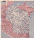
| Date: | 1942 |
|---|---|
| Description: | This colored road map shows automobile roads in Wisconsin as well as portions of nearby states. Information on the quality and type of any road shown (pave... |
If you didn't find the material you searched for, our Library Reference Staff can help.
Call our reference desk at 608-264-6535 or email us at: