 Filter: Categories of Wisconsin Historical Images
Filter: FULL_DATE of 1941
Filter: Subject of parks
Filter: Categories of Wisconsin Historical Images
Filter: FULL_DATE of 1941
Filter: Subject of parks

| Date: | 1941 |
|---|---|
| Description: | A map of the area south of Ripon and Sheboygan and east of Waterloo and Janesville, showing the route of the Chicago, North Shore and Milwaukee Railroad in... |
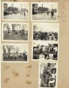
| Date: | 1941 |
|---|---|
| Description: | Page from a scrapbook kept by Neighborhood House, with children crossing the street in front of the settlement house, gathering Easter eggs in the park, po... |

| Date: | 1941 |
|---|---|
| Description: | Color coded map in pink, yellow, green, and brown of Milwaukee County State and County trunk highways. The map includes a legend of symbols: "STEAM RAIL RO... |

| Date: | 1941 |
|---|---|
| Description: | This map highlights the fishing district and shows labeled rivers, lakes, cities, county boundaries and points of interest. The map includes a list of trai... |
If you didn't find the material you searched for, our Library Reference Staff can help.
Call our reference desk at 608-264-6535 or email us at: