 Filter: Categories of Wisconsin Historical Images
Filter: FULL_DATE of 1941
Filter: Subject of michigan, lake
Filter: Categories of Wisconsin Historical Images
Filter: FULL_DATE of 1941
Filter: Subject of michigan, lake

| Date: | 1941 |
|---|---|
| Description: | Official highway map of Wisconsin, "the playground of the Midwest," showing the state transportation network prior to World War II. |

| Date: | 1941 |
|---|---|
| Description: | A map of the area south of Ripon and Sheboygan and east of Waterloo and Janesville, showing the route of the Chicago, North Shore and Milwaukee Railroad in... |

| Date: | 1941 |
|---|---|
| Description: | Wisconsin counties, towns, cities, and selected villages, as well as the Menominee Indian Reservation are identified on this U.S. Bureau of the Census map ... |
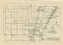
| Date: | 1941 |
|---|---|
| Description: | A map shows early settlers by name and date, industries, the Chicago & North Western rail line, roads, and depths and net lines in Lake Michigan. Text prov... |

| Date: | 1941 |
|---|---|
| Description: | This 1941 tourist map of Washington Island, Wisconsin, shows points of interest and places of business. Some information is shown pictorially. Rock, Hog, D... |

| Date: | 1941 |
|---|---|
| Description: | Color coded map in pink, yellow, green, and brown of Milwaukee County State and County trunk highways. The map includes a legend of symbols: "STEAM RAIL RO... |
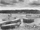
| Date: | 1941 |
|---|---|
| Description: | Three boats, including the Sea Skipper, are tied to a wooden pier near the beach at Sister Bay. Another craft, the Flussheim of Sister Bay, i... |
If you didn't find the material you searched for, our Library Reference Staff can help.
Call our reference desk at 608-264-6535 or email us at: