Filter: Categories of Wisconsin Historical Images
Filter: FULL_DATE of 1941
Filter: Subject of indians of north america
Filter: Categories of Wisconsin Historical Images
Filter: FULL_DATE of 1941
Filter: Subject of indians of north america

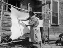
| Date: | 1941 |
|---|---|
| Description: | Joe Stoddard of the Chippewa tribe harvesting wild rice on the Bad River Indian Reservation. |
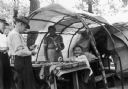
| Date: | 1941 |
|---|---|
| Description: | Suzie Redhorn at her stand at Dells Park selling her beads to tourists. |
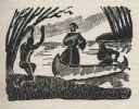
| Date: | 1941 |
|---|---|
| Description: | Woodcut illustration of a missionary priest wearing a robe standing in the fore of a canoe as it comes ashore paddled by a person in the aft. An Indian on ... |
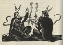
| Date: | 1941 |
|---|---|
| Description: | Woodcut illustration of two seated figures smoking pipes. |
| Date: | 1941 |
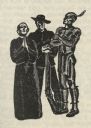
|---|---|
| Description: | Woodcut illustration of three standing figures, possibly a missionary, a fur trader, and an American Indian, depicting Wisconsin history. |

| Date: | 1941 |
|---|---|
| Description: | Hand-drawn, watercolor and ink, map of Lake Mendota. Locations and many small figures appear around the shore with explanations referring to Indian legends... |

| Date: | 1941 |
|---|---|
| Description: | This pictorial map of Wisconsin with historical text highlights the history of the state and identifies places of interest, Indian villages, missions, trad... |

| Date: | 1941 |
|---|---|
| Description: | Wisconsin counties, towns, cities, and selected villages, as well as the Menominee Indian Reservation are identified on this U.S. Bureau of the Census map ... |

| Date: | 1941 |
|---|---|
| Description: | A pictorial map of Lake Mendota that shows Indian sites and legends associated with the Lake and its surrounding area. Some of those mentioned on the map i... |

| Date: | 1941 |
|---|---|
| Description: | This pictorial map shows sites related to Indian legends, mounds, and trails in the Chain O' Lakes region in southwestern Waupaca County, Wisconsin. |

| Date: | 1941 |
|---|---|
| Description: | This map is ink and watercolor on cardboard and shows Native American legends and villages pictorially. Trails are also shown. |
If you didn't find the material you searched for, our Library Reference Staff can help.
Call our reference desk at 608-264-6535 or email us at: