 Filter: Categories of Wisconsin Historical Images
Filter: FULL_DATE of 1940
Filter: Subject of tourism
Filter: Categories of Wisconsin Historical Images
Filter: FULL_DATE of 1940
Filter: Subject of tourism
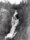
| Date: | 1940 |
|---|---|
| Description: | Big Manitou Falls with trees and observation area. |
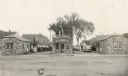
| Date: | 1940 |
|---|---|
| Description: | Automobiles parked outside the Poplar Tourist Court. |

| Date: | 1940 |
|---|---|
| Description: | This tourist map of Door County, Wisconsin, lists the points of interest and tourist hotels, cabins and cottages in the area. Ferry schedules to Washington... |

| Date: | 1940 |
|---|---|
| Description: | Shows Milwaukee and Waukesha counties, and parts of Dodge, Washington, Ozaukee, Jefferson, Walworth, and Racine counties. Includes indexes of "Cities, Town... |
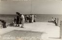
| Date: | 1940 |
|---|---|
| Description: | Photographic postcard view looking out at people standing, and some fishing, on the Northport pier at Death's Door, with the bay in the background. |
| Date: | 1940 |
|---|---|
| Description: | Black and white photographic postcard of people on the shoreline and on the pier at Death's Door. Signs on a tree near a snack stand on the right read: "Sm... |

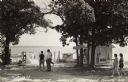
| Date: | 1940 |
|---|---|
| Description: | This pictorial map shows points of interest, recreation activities, and highways in the vicinity of the restaurant and covers the Wisconsin River Valley be... |

| Date: | 1940 |
|---|---|
| Description: | This map shows lakes, roads, car trails, foot trails, railroads, resorts and camps, and fire towers. The map includes an inset location map and pictorial d... |
If you didn't find the material you searched for, our Library Reference Staff can help.
Call our reference desk at 608-264-6535 or email us at: