 Filter: Categories of Wisconsin Historical Images
Filter: FULL_DATE of 1940
Filter: Subject of streams
Filter: Categories of Wisconsin Historical Images
Filter: FULL_DATE of 1940
Filter: Subject of streams

| Date: | 1940 |
|---|---|
| Description: | This maps shows the areas in Monroe, Jackson, and Juneau counties, Wisconsin, where U.S. Army maneuvers were held in August 1940. Highways and roads, commu... |
| Date: | 1940 |
|---|---|
| Description: | This map shows cities and villages, roads, railroads, and lakes and streams in northern Sawyer, northeastern Washburn, southeastern Douglas, and southern B... |

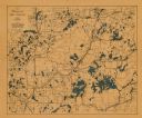
| Date: | 1940 |
|---|---|
| Description: | This map of Taylor County, Wisconsin, shows the township and range grid, towns, sections, cities and villages, railroads, roads, creameries and cheese fact... |

| Date: | 1940 |
|---|---|
| Description: | Map shows hydrography and location of game fish in part of Vilas County, Wisconsin and Gogebic County, Michigan. |
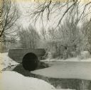
| Date: | 1940 |
|---|---|
| Description: | View from snowy shoreline towards a bridge over Wingra Creek, between Lake Wingra and Lake Monona, in Vilas Park. The road over the bridge leads into the U... |

| Date: | 1940 |
|---|---|
| Description: | A picturesque view of three people in a rowboat on Otter Creek, with Government Island in the background. A seal at lower right identifies Estberg Photo Se... |

| Date: | 1940 |
|---|---|
| Description: | Three barefoot boys are standing on a boulder on the shore of a lake or stream in a wooded area. One boy is holding a thin stick which has a fishing line a... |
If you didn't find the material you searched for, our Library Reference Staff can help.
Call our reference desk at 608-264-6535 or email us at: