Filter: Categories of Wisconsin Historical Images
Filter: FULL_DATE of 1940
Filter: Subject of rivers
Filter: Categories of Wisconsin Historical Images
Filter: FULL_DATE of 1940
Filter: Subject of rivers
| Date: | 1940 |
|---|---|
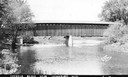
| Description: | Exterior view of the last covered bridge in Wisconsin. Caption reads: "Covered Bridge Near Cedarburg, Wis." |
| Date: | 1940 |
|---|---|
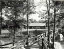
| Description: | People on a rustic bridge over river at Copper Falls State Park. A long log building is in the background on the other side of the river. |
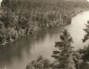
| Date: | 1940 |
|---|---|
| Description: | Elevated view of a canoe on the St. Croix River with wooded areas on both sides within the Interstate State Park. Established in 1900, Interstate Park was... |
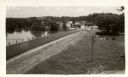
| Date: | 1940 |
|---|---|
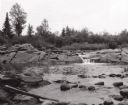
| Description: | View of town from the south, with the Baraboo River on the other side of the road. |
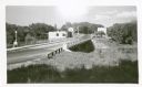
| Date: | 1940 |
|---|---|
| Description: | The bridge over Crawfish River. Buildings are on the other side of the bridge. |
| Date: | 1940 |
|---|---|
| Description: | Colsac Ferry across the Wisconsin River at Merrimac. There is a bridge across the river in the background on the left. |
| Date: | 1940 |
|---|---|
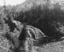
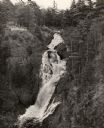
| Description: | Big Manitou Falls on the Black River. It is referred to as the "lower falls" in the park. This 165-foot waterfall is recognized as the highest in the state... |

| Date: | 1940 |
|---|---|
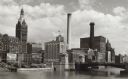
| Description: | Aerial view of city, river and harbor. Two smokestacks are on either side of the river mouth. |
| Date: | 1940 |
|---|---|
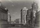
| Description: | View from the Wisconsin Avenue Bridge. A building on the left has a large sign for Gimbel's on its roof. Beyond the river in the background are two large s... |
| Date: | 1940 |
|---|---|
| Description: | A view north of Wells Street with a bridge on the right. Two large smokestacks, and a tall building with a clock break up the skyline. On the left is a bil... |
| Date: | 1940 |
|---|---|
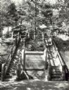
| Description: | Two rustic stairways leading down to the Bad River at Copper Falls State Park. At the bottom of the stairs is a sign telling the geological story of Copper... |
| Date: | 1940 |
|---|---|
| Description: | View from the second floor balcony of the Charles A Grignon House at Kaukauna showing the historic boat canal and the Fox River beyond it. |
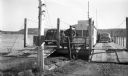
| Date: | 1940 |
|---|---|
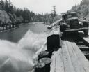
| Description: | An International truck is dumping logs into the North River while positioned on a wooden platform high above the bank. |

| Date: | 1940 |
|---|---|
| Description: | This map of southeastern Wisconsin depicts the Rock and Milwaukee rivers and the Kettle Moraine area. Cities and villages are identified. Stamp stating "Po... |

| Date: | 1940 |
|---|---|
| Description: | Map of Milwaukee County showing the metropolitan area, in yellow, and the proposed connecting of parkways and boulevards in green. The map also identifies ... |

| Date: | 1940 |
|---|---|
| Description: | A map of Milwaukee County, showing the route of the county tour of Milwaukee in the dark line, as well as identifying other roads, streets, and the Root, M... |

| Date: | 1940 |
|---|---|
| Description: | This map is pen and ink on paper and is 1 map consisting of 12 sheets. This map includes a numbered key labeling each area, all of which are represented ... |

| Date: | 1940 |
|---|---|
| Description: | Shows Milwaukee and Waukesha counties, and parts of Dodge, Washington, Ozaukee, Jefferson, Walworth, and Racine counties. Includes indexes of "Cities, Town... |
If you didn't find the material you searched for, our Library Reference Staff can help.
Call our reference desk at 608-264-6535 or email us at: