 Filter: Categories of Wisconsin Historical Images
Filter: FULL_DATE of 1940
Filter: Subject of michigan, lake
Filter: Categories of Wisconsin Historical Images
Filter: FULL_DATE of 1940
Filter: Subject of michigan, lake
| Date: | 1940 |
|---|---|
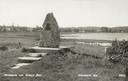
| Description: | Memorial to the Moravians who arrived in Eagle Bay in 1853. |

| Date: | 1940 |
|---|---|
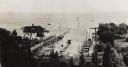
| Description: | Aerial view of city, river and harbor. Two smokestacks are on either side of the river mouth. |

| Date: | 1940 |
|---|---|
| Description: | Monument in Juneau Park. A man is sitting on a bench, with Lake Michigan behind. |

| Date: | 1940 |
|---|---|
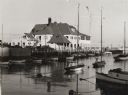
| Description: | Exterior view of the club. A mast with flags stands outside of the club on the pier. |
| Date: | 1940 |
|---|---|
| Description: | Exterior of building from shoreline looking out to Lake Michigan. Along the pier are numerous docked boats and sailboats moored in water. On the left autom... |
| Date: | 1940 |
|---|---|
| Description: | View from hill of the yacht club, with Lake Michigan behind. In the distance is the jetty, and the road along the shoreline is N. Lincoln Memorial Drive. T... |

| Date: | 1940 |
|---|---|
| Description: | This map of southeastern Wisconsin depicts the Rock and Milwaukee rivers and the Kettle Moraine area. Cities and villages are identified. Stamp stating "Po... |

| Date: | 1940 |
|---|---|
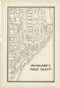
| Description: | Map of Milwaukee County showing the metropolitan area, in yellow, and the proposed connecting of parkways and boulevards in green. The map also identifies ... |

| Date: | 1940 |
|---|---|
| Description: | A map of Milwaukee County, showing the route of the county tour of Milwaukee in the dark line, as well as identifying other roads, streets, and the Root, M... |

| Date: | 1940 |
|---|---|
| Description: | This map is pen and ink on paper and is 1 map consisting of 12 sheets. This map includes a numbered key labeling each area, all of which are represented ... |

| Date: | 1940 |
|---|---|
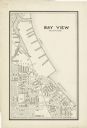
| Description: | Shows Milwaukee and Waukesha counties, and parts of Dodge, Washington, Ozaukee, Jefferson, Walworth, and Racine counties. Includes indexes of "Cities, Town... |
| Date: | 1940 |
|---|---|
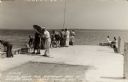
| Description: | Photographic postcard view looking out at people standing, and some fishing, on the Northport pier at Death's Door, with the bay in the background. |
| Date: | 1940 |
|---|---|
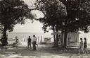
| Description: | Black and white photographic postcard of people on the shoreline and on the pier at Death's Door. Signs on a tree near a snack stand on the right read: "Sm... |
| Date: | 1940 |
|---|---|
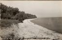
| Description: | Black and white photographic postcard view along the shoreline of Lake Michigan at Northport. |

| Date: | 1940 |
|---|---|
| Description: | Color enhanced postcard view of fisherman's shacks on the outlet of Logan's creek on the shore of Lake Michigan. |
| Date: | 1940 |
|---|---|
| Description: | This map is pen and ink on paper and is map 5 in a series of 12. The map shows streets, the Milwaukee River, Lake Michigan, and railroad tracks. |
| Date: | 1940 |
|---|---|
| Description: | This map is pen and ink on paper and is map 12 in a series of 12. The map shows streets, railroad lines, the Kinnickinnic River, and Lake Michigan. |

| Date: | 1940 |
|---|---|
| Description: | A man is standing and looking at the door of the boathouse on the beach near the Twin River (Rawley) Point Lighthouse. The boathouse has stone sides and a ... |

| Date: | 1940 |
|---|---|
| Description: | An unidentified woman is posing sitting on the sand and looking toward Lake Michigan. The newly built shelter house, with its large windowed bay and massiv... |

| Date: | 1940 |
|---|---|
| Description: | View from pier towards a young couple sitting in the back of a wooden boat tied to a pier in Peninsula State Park. Fish Creek Harbor is in the background, ... |
If you didn't find the material you searched for, our Library Reference Staff can help.
Call our reference desk at 608-264-6535 or email us at: