 Filter: Categories of Wisconsin Historical Images
Filter: FULL_DATE of 1940
Filter: Subject of lakes
Filter: Categories of Wisconsin Historical Images
Filter: FULL_DATE of 1940
Filter: Subject of lakes
| Date: | 1940 |
|---|---|
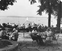
| Description: | Summertime view of people at tables on University of Wisconsin-Madison Memorial Union terrace, looking out to canoes and sailboats on the lake. In the back... |

| Date: | 1940 |
|---|---|
| Description: | Aerial view looking east over the center of the city and the University of Wisconsin-Madison campus. |
| Date: | 1940 |
|---|---|
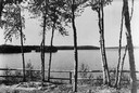
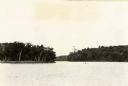
| Description: | View of trees along a fence in front of Boulder Lake. |
| Date: | 1940 |
|---|---|
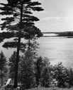
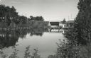
| Description: | View down steep hill through trees towards a rowboat tied to a pier on High Lake, with the far shoreline in the distance. |
| Date: | 1940 |
|---|---|
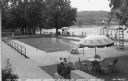
| Description: | View towards swimming pool towards people relaxing and sitting around the pool near the lake at the Baptist Assembly Grounds. Caption reads: "The Pool Nort... |
| Date: | 1940 |
|---|---|
| Description: | View of Taylor Lake and the entrance to Chain O' Lakes. |
| Date: | 1940 |
|---|---|
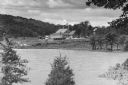
| Description: | Rest Lake Dam of Manitowish River, Manitowish. Photograph taken from Vance Lake Highway (old Highway 51, now Highway W). |

| Date: | 1940 |
|---|---|
| Description: | Monument in Juneau Park. A man is sitting on a bench, with Lake Michigan behind. |
| Date: | 1940 |
|---|---|
| Description: | A view of a Northland Camp building from across Lake Iliff. The camp was operated as an auxiliary of the German-American Bund, the American Nazi Organizati... |
| Date: | 1940 |
|---|---|
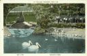
| Description: | A postcard of the Henry Vilas Zoo (Vilas Park Zoo) depicting aquatic fowl, with an inset of a sea lion on a rock. Caption reads: "At the Zoo, Madison, Wis.... |

| Date: | 1940 |
|---|---|
| Description: | Aerial view of the west side of the University of Wisconsin-Madison Campus looking towards Bascom Hill. Lake Mendota is in the background on the right. |
| Date: | 1940 |
|---|---|
| Description: | This map shows cities and villages, roads, railroads, and lakes and streams in northern Sawyer, northeastern Washburn, southeastern Douglas, and southern B... |

| Date: | 1940 |
|---|---|
| Description: | This map of Taylor County, Wisconsin, shows the township and range grid, towns, sections, cities and villages, railroads, roads, creameries and cheese fact... |

| Date: | 1940 |
|---|---|
| Description: | This tourist map of Door County, Wisconsin, lists the points of interest and tourist hotels, cabins and cottages in the area. Ferry schedules to Washington... |

| Date: | 1940 |
|---|---|
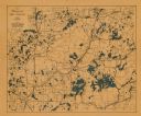
| Description: | Map shows hydrography and location of game fish in part of Vilas County, Wisconsin and Gogebic County, Michigan. |

| Date: | 1940 |
|---|---|
| Description: | This map is pen and ink on paper and is 1 map consisting of 12 sheets. This map includes a numbered key labeling each area, all of which are represented ... |

| Date: | 1940 |
|---|---|
| Description: | Shows Milwaukee and Waukesha counties, and parts of Dodge, Washington, Ozaukee, Jefferson, Walworth, and Racine counties. Includes indexes of "Cities, Town... |
| Date: | 1940 |
|---|---|
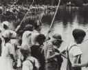
| Description: | View of large crowd of boys and girls fishing along the shoreline with bamboo poles at a lake. Very likely a sponsored "fishing contest." There are a few p... |

| Date: | 1940 |
|---|---|
| Description: | This map of Beaver Dam pictorially shows the history of the town. The map was made for the 100th anniversary celebration of Beaver Dam in 1941. The map inc... |
If you didn't find the material you searched for, our Library Reference Staff can help.
Call our reference desk at 608-264-6535 or email us at:
