 Filter: Categories of Wisconsin Historical Images
Filter: FULL_DATE of 1940
Filter: County of Sawyer
Filter: Categories of Wisconsin Historical Images
Filter: FULL_DATE of 1940
Filter: County of Sawyer
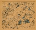
| Date: | 1940 |
|---|---|
| Description: | This map shows cities and villages, roads, railroads, and lakes and streams in northern Sawyer, northeastern Washburn, southeastern Douglas, and southern B... |
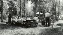
| Date: | 1940 |
|---|---|
| Description: | A group of people having a picnic at the Ojibwa Roadside Park. There are several cars and trucks in the background, and a small building. The picnic tables... |
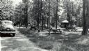
| Date: | 1940 |
|---|---|
| Description: | Several small groups of people are scattered about the roadside park among picnic tables. There are parked automobiles, and a small building. |

| Date: | 1940 |
|---|---|
| Description: | Man standing near a tree stump in the Ojibwa Roadside Park. Two automobiles are parked in the background. The verso of the photograph reads: "Custodian Whi... |

| Date: | 1940 |
|---|---|
| Description: | This blue line print map traced from aerial survey mosaic shows reservation boundary, roads, trails, and railroads. Color manuscript annotations show triba... |
If you didn't find the material you searched for, our Library Reference Staff can help.
Call our reference desk at 608-264-6535 or email us at: