 Filter: Categories of Wisconsin Historical Images
Filter: FULL_DATE of 1940
Filter: Creator Name of Unknown
Filter: Subject of human settlements
Filter: Categories of Wisconsin Historical Images
Filter: FULL_DATE of 1940
Filter: Creator Name of Unknown
Filter: Subject of human settlements

| Date: | 1940 |
|---|---|
| Description: | A view of a row of brick and stone buildings leading towards Crosby Hall. Trees line the sidewalk. |

| Date: | 1940 |
|---|---|
| Description: | A view of the street that runs through the Dartmouth College campus. Trees and buildings line the way, with a stone "Slow Keep Right" obelisk in the middl... |
| Date: | 1940 |
|---|---|
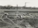
| Description: | Elevated view of foundation of the house built by Dominique DuCharme in 1790 and enlarged by Augustin Grignon after 1804. The Grignon family resided in the... |
| Date: | 1940 |
|---|---|
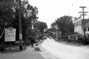
| Description: | A man walks down Main Street towards an Amoco station and parked cars. To his left, a sign advertises "The Art Center" located on Hoyt's Lane. The Leavit... |

| Date: | 1940 |
|---|---|
| Description: | View of the village green, with rustic bridges and dwellings in the background. Automobiles are further down the street. |

| Date: | 1940 |
|---|---|
| Description: | Associated Press journalist Alvin Steinkopf, formerly of Milwaukee, photographed on the streets of Berlin. Steinkopf was in Berlin until after Pearl Harbor... |

| Date: | 1940 |
|---|---|
| Description: | This map of southeastern Wisconsin depicts the Rock and Milwaukee rivers and the Kettle Moraine area. Cities and villages are identified. Stamp stating "Po... |

| Date: | 1940 |
|---|---|
| Description: | Map of Milwaukee County showing the metropolitan area, in yellow, and the proposed connecting of parkways and boulevards in green. The map also identifies ... |

| Date: | 1940 |
|---|---|
| Description: | A map of Milwaukee County, showing the route of the county tour of Milwaukee in the dark line, as well as identifying other roads, streets, and the Root, M... |

| Date: | 1940 |
|---|---|
| Description: | This maps shows the areas in Monroe, Jackson, and Juneau counties, Wisconsin, where U.S. Army maneuvers were held in August 1940. Highways and roads, commu... |

| Date: | 1940 |
|---|---|
| Description: | This map of Taylor County, Wisconsin, shows the township and range grid, towns, sections, cities and villages, railroads, roads, creameries and cheese fact... |

| Date: | 1940 |
|---|---|
| Description: | Group portrait of the Orioles, members of a club for ten-year-old girls at Neighborhood House. A former worker at the settlement house then working in a ho... |

| Date: | 1940 |
|---|---|
| Description: | Page from a scrapbook kept by Neighborhood House, with members of the Orioles, a girls' club at the settlement house. There are six images of members displ... |

| Date: | 1940 |
|---|---|
| Description: | Map features advertisements for local businesses on the left and bottom. Map includes a "LEGEND" and "DIRECTORY OF CHURCHES". Streets are labeled as are so... |
| Date: | 1940 |
|---|---|
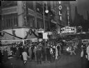
| Description: | Slightly elevated view from street corner at Broadway and West 50th Street of the Rivoli Theater in Times Square when it was screening the movie "Foreign C... |

| Date: | 1940 |
|---|---|
| Description: | This map of La Crosse shows different types of land zoning: residence, multiple dwelling, local business, commercial, light industrial, heavy industrial, w... |

| Date: | 1940 |
|---|---|
| Description: | Postcard with retouched photomechanical reproduction, printed in color, of an elevated view of the Campus Martius and surrounding buildings in downtown. Ca... |

| Date: | 1940 |
|---|---|
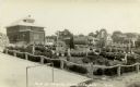
| Description: | Toots Sullivan (on left) and Emil Picha stand in front of the exterior of the Toot's Standard Gas Station at the intersection of Mill Street and Prairie Av... |
| Date: | 1940 |
|---|---|
| Description: | Photograph postcard of the park at the Grotto, with houses in the background. Caption reads: "Park at Grotto, Dickeyville, Wis." |

| Date: | 1940 |
|---|---|
| Description: | Looking north on Bridge Street from Spring Street intersection. In foreground, left, is a bank. In foreground, right, is a restaurant with a neon sign that... |
If you didn't find the material you searched for, our Library Reference Staff can help.
Call our reference desk at 608-264-6535 or email us at: