 Filter: Categories of Wisconsin Historical Images
Filter: FULL_DATE of 1940
Filter: Type of Map or Atlas
Filter: Subject of streets
Filter: Categories of Wisconsin Historical Images
Filter: FULL_DATE of 1940
Filter: Type of Map or Atlas
Filter: Subject of streets

| Date: | 1940 |
|---|---|
| Description: | Map of Milwaukee County showing the metropolitan area, in yellow, and the proposed connecting of parkways and boulevards in green. The map also identifies ... |

| Date: | 1940 |
|---|---|
| Description: | A map of Milwaukee County, showing the route of the county tour of Milwaukee in the dark line, as well as identifying other roads, streets, and the Root, M... |

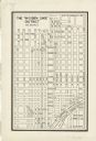
| Date: | 1940 |
|---|---|
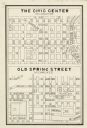
| Description: | This map is pen and ink on paper and is 1 map consisting of 12 sheets. This map includes a numbered key labeling each area, all of which are represented ... |

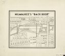
| Date: | 1940 |
|---|---|
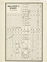
| Description: | Map features advertisements for local businesses on the left and bottom. Map includes a "LEGEND" and "DIRECTORY OF CHURCHES". Streets are labeled as are so... |

| Date: | 1940 |
|---|---|
| Description: | Shows property ownership, store divisions, and bus stops. "Sept. 12, 1940." Oriented with north to the right. Insets: "Trade area" location map and enlarge... |

| Date: | 1940 |
|---|---|
| Description: | This map of the Wisconsin Dells shows original plats and various additions. Some streets are labeled as is the Wisconsin River. The map was originally crea... |

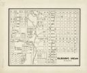
| Date: | 1940 |
|---|---|
| Description: | This map of Beaver Dam pictorially shows the history of the town. The map was made for the 100th anniversary celebration of Beaver Dam in 1941. The map inc... |

| Date: | 1940 |
|---|---|
| Description: | This map of La Crosse shows different types of land zoning: residence, multiple dwelling, local business, commercial, light industrial, heavy industrial, w... |

| Date: | 1940 |
|---|---|
| Description: | This ward map shows streets, the Nemadji River, and addition and division boundaries. Also included is a list of members of the Douglas County Board town, ... |
| Date: | 1940 |
|---|---|
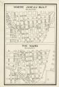
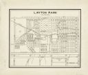
| Description: | This map is pen and ink on paper and is map 2 in a series of 12. The map shows streets, the Milwaukee River, and railroad tracks. |
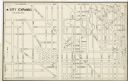
| Date: | 1940 |
|---|---|
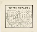
| Description: | This map is pen and ink on paper and is map 3 in a series of 12. The map shows streets, the Milwaukee River, and railroad tracks. |
| Date: | 1940 |
|---|---|
| Description: | This map is pen and ink on paper and is map 3 in a series of 12. The map shows streets, and the Milwaukee River. |
| Date: | 1940 |
|---|---|
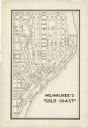
| Description: | This map is pen and ink on paper and is map 5 in a series of 12. The map shows streets, the Milwaukee River, Lake Michigan, and railroad tracks. |
| Date: | 1940 |
|---|---|
| Description: | This map is pen and ink on paper and is map 6 in a series of 12. The map shows streets, and the Milwaukee River. |
| Date: | 1940 |
|---|---|
| Description: | This map is pen and ink on paper and is map 7 in a series of 12. The map shows streets and a railroad line. |
| Date: | 1940 |
|---|---|
| Description: | This map is pen and ink on paper and is map 8 in a series of 12. The map shows streets and a railroad line. |
| Date: | 1940 |
|---|---|
| Description: | This map is pen and ink on paper and is map 9 in a series of 12. The map shows streets and railroad lines. |
| Date: | 1940 |
|---|---|
| Description: | This map is pen and ink on paper and is map 10 in a series of 12. The map shows streets and railroad lines. |
| Date: | 1940 |
|---|---|
| Description: | This map is pen and ink on paper and is map 11 in a series of 12. The map shows streets. |
| Date: | 1940 |
|---|---|
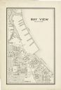
| Description: | This map is pen and ink on paper and is map 12 in a series of 12. The map shows streets, railroad lines, the Kinnickinnic River, and Lake Michigan. |
If you didn't find the material you searched for, our Library Reference Staff can help.
Call our reference desk at 608-264-6535 or email us at: