 Filter: Categories of Wisconsin Historical Images
Filter: FULL_DATE of 1939
Filter: Subject of michigan, lake
Filter: Categories of Wisconsin Historical Images
Filter: FULL_DATE of 1939
Filter: Subject of michigan, lake
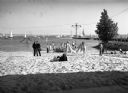
| Date: | 1939 |
|---|---|
| Description: | A beach on Lake Michigan near the Milwaukee Yacht Club. Men, women, and children relax on the beach. In the background many boats are on the water. |

| Date: | 1939 |
|---|---|
| Description: | This nine-part map from the U.S. Bureau of Public Roads identifies federal and state highways in Wisconsin by pavement type. County, forest, park, and publ... |

| Date: | 1939 |
|---|---|
| Description: | This illustrated map shows counties, highways, rivers, roads, present and proposed state parks and forests, proposed state parkways, proposed state monumen... |

| Date: | 1939 |
|---|---|
| Description: | This brochure was intended for tourists and shows resorts, lakes and railroads in northwestern Wisconsin and part of Michigan’s upper peninsula. Also inclu... |

| Date: | 1939 |
|---|---|
| Description: | This map shows the state trunk highway system and county trunk highways. This map show surface type on state and county trunk highways and the locations of... |
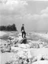
| Date: | 1939 |
|---|---|
| Description: | An unidentified man is standing on a boulder on the beach looking out at Lake Michigan. |
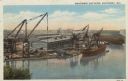
| Date: | 1939 |
|---|---|
| Description: | Elevated view of the Manitowoc shipyards on Lake Michigan. Two ships are being built. Caption reads: "Manitowoc Shipyards, Manitowoc, Wis." |
If you didn't find the material you searched for, our Library Reference Staff can help.
Call our reference desk at 608-264-6535 or email us at: