Filter: Categories of Wisconsin Historical Images
Filter: FULL_DATE of 1939
Filter: Subject of indians of north america
Filter: Categories of Wisconsin Historical Images
Filter: FULL_DATE of 1939
Filter: Subject of indians of north america
| Date: | 1939 |
|---|---|
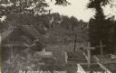
| Description: | Burl Briggs (far left), and unknown companions pose near a linear burial mound on Picnic Point on the University of Wisconsin-Madison campus. |
| Date: | 1939 |
|---|---|
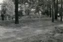
| Description: | Burl Briggs (right), and an unknown companion pose behind a linear burial mound on the University of Wisconsin-Madison campus. |
| Date: | 1939 |
|---|---|
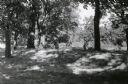
| Description: | A man poses behind a large conical Native American burial mound near the center of Picnic Point on the University of Wisconsin-Madison campus. |

| Date: | 1939 |
|---|---|
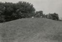
| Description: | A man poses behind a conical Native American burial mound near the west end of Picnic Point on the University of Wisconsin-Madison campus. |

| Date: | 1939 |
|---|---|
| Description: | A color, pictorial map. Scale: 10 miles to the inch. Shows state parks and forests, proposed state parkways, proposed state monuments and memorials, nation... |

| Date: | 1939 |
|---|---|
| Description: | This map shows the towns to Gingles, Sanborn, and Guney as well as Chequamegon Bay, Kakagon River, White River, Marengo River, Bad River, Potato River, Vau... |

| Date: | 1939 |
|---|---|
| Description: | Label submitted to the state of Wisconsin for trademark registration. "Superfine Marathon Beer, Marathon City Brewing Company." In the foreground of the im... |

| Date: | 1939 |
|---|---|
| Description: | This nine-part map from the U.S. Bureau of Public Roads identifies federal and state highways in Wisconsin by pavement type. County, forest, park, and publ... |

| Date: | 1939 |
|---|---|
| Description: | This illustrated map shows counties, highways, rivers, roads, present and proposed state parks and forests, proposed state parkways, proposed state monumen... |

| Date: | 1939 |
|---|---|
| Description: | This map shows the state trunk highway system and county trunk highways. This map show surface type on state and county trunk highways and the locations of... |

| Date: | 1939 |
|---|---|
| Description: | Waist-up outdoor portrait of Cecelia Blackdeer (1917-1990), the daughter of Charles and Carolind Decorah Blackdeer standing in front of a flowering tree. S... |

| Date: | 1939 |
|---|---|
| Description: | Two boys are standing outdoors. Behind them is a bench along the side of a brick building. |

| Date: | 1939 |
|---|---|
| Description: | Two young people posing with a Native American man in a feather headdress and beaded clothing on sidewalk in front of a brick building. |
If you didn't find the material you searched for, our Library Reference Staff can help.
Call our reference desk at 608-264-6535 or email us at: