 Filter: Categories of Wisconsin Historical Images
Filter: FULL_DATE of 1939
Filter: Subject of human settlements
Filter: Categories of Wisconsin Historical Images
Filter: FULL_DATE of 1939
Filter: Subject of human settlements

| Date: | 1939 |
|---|---|
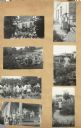
| Description: | Image from the Garden Club record book kept by Neighborhood House, with the winner in the Senior category garden competition, Mrs. Ora Smith, sitting on th... |
| Date: | 1939 |
|---|---|
| Description: | Page from a scrapbook kept by Neighborhood House, with Junior Garden Club members on an outing to Babcock Memorial Gardens at the University of Wisconsin; ... |

| Date: | 1939 |
|---|---|
| Description: | Image from a scrapbook kept by Neighborhood House, with a man and three boys positioning a ladder to hang holiday decorations on the exterior of the settle... |

| Date: | 1939 |
|---|---|
| Description: | This map of Sauk County, Wisconsin, shows the township and range grid, towns, sections, cities and villages, roads, railroads, lakes and rivers, schools, a... |

| Date: | 1939 |
|---|---|
| Description: | This 1939 map of Barron County, Wisconsin, shows the township and range grid, sections, cities and villages, and lakes and streams in the county. It lacks ... |

| Date: | 1939 |
|---|---|
| Description: | This map of Walworth County, Wisconsin, shows the township and range grid, sections, cities and town, and lakes and streams in the county. It lacks the key... |

| Date: | 1939 |
|---|---|
| Description: | This 1939 map of Saint Croix County, Wisconsin, shows the township and range grid, cities and villages, and lakes and streams. |

| Date: | 1939 |
|---|---|
| Description: | This is a zoning map of Wauwatosa with a key of districts including agricultural, resident, business, commercial, and industrial. The map features labeled ... |
| Date: | 1939 |
|---|---|
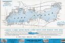
| Description: | A brochure for the Wisconsin Transportation Co. includes a map of Lake Geneva with towns and shoreline property owners identified. Black Point, on the sout... |

| Date: | 1939 |
|---|---|
| Description: | This brochure was intended for tourists and shows resorts, lakes and railroads in northwestern Wisconsin and part of Michigan’s upper peninsula. Also inclu... |

| Date: | 1939 |
|---|---|
| Description: | This map shows the state trunk highway system and county trunk highways. This map show surface type on state and county trunk highways and the locations of... |

| Date: | 1939 |
|---|---|
| Description: | Three-quarter view from front left of a D-300-H truck used for garbage collection. Hercules body hydraulic hoist. Rounded sliding covers. Waterproof tailga... |

| Date: | 1939 |
|---|---|
| Description: | View from street of men working on a Works Progress Administration project. A group of men are standing and holding a beam upright in a trench, with a chai... |

| Date: | 1939 |
|---|---|
| Description: | View across street towards men working on a Works Progress Administration project. Three men are standing and holding a board with a chain attached to it n... |

| Date: | 1939 |
|---|---|
| Description: | View across street towards a fleet of Internationals delivered in the spring to Post Office Department. |

| Date: | 1939 |
|---|---|
| Description: | This map originally dated March 18, 1920 and revised for this edition. The map shows the original meander line of 'Shebowegan Lake' established by 1850 sur... |

| Date: | 1939 |
|---|---|
| Description: | A group of people stand in a graveyard in Lemberg, Poland as German victims of a massacre are buried. |

| Date: | 1939 |
|---|---|
| Description: | A German person who fell victim to a massacre by Poles in Lemberg, Poland as the Nazis invaded. |

| Date: | 1939 |
|---|---|
| Description: | A German person who fell victim to a massacre by Poles in Lemberg, Poland as the Nazis invaded. |

| Date: | 1939 |
|---|---|
| Description: | A German person who fell victim to a massacre by Poles in Lemberg, Poland as the Nazis invaded. |
If you didn't find the material you searched for, our Library Reference Staff can help.
Call our reference desk at 608-264-6535 or email us at: